
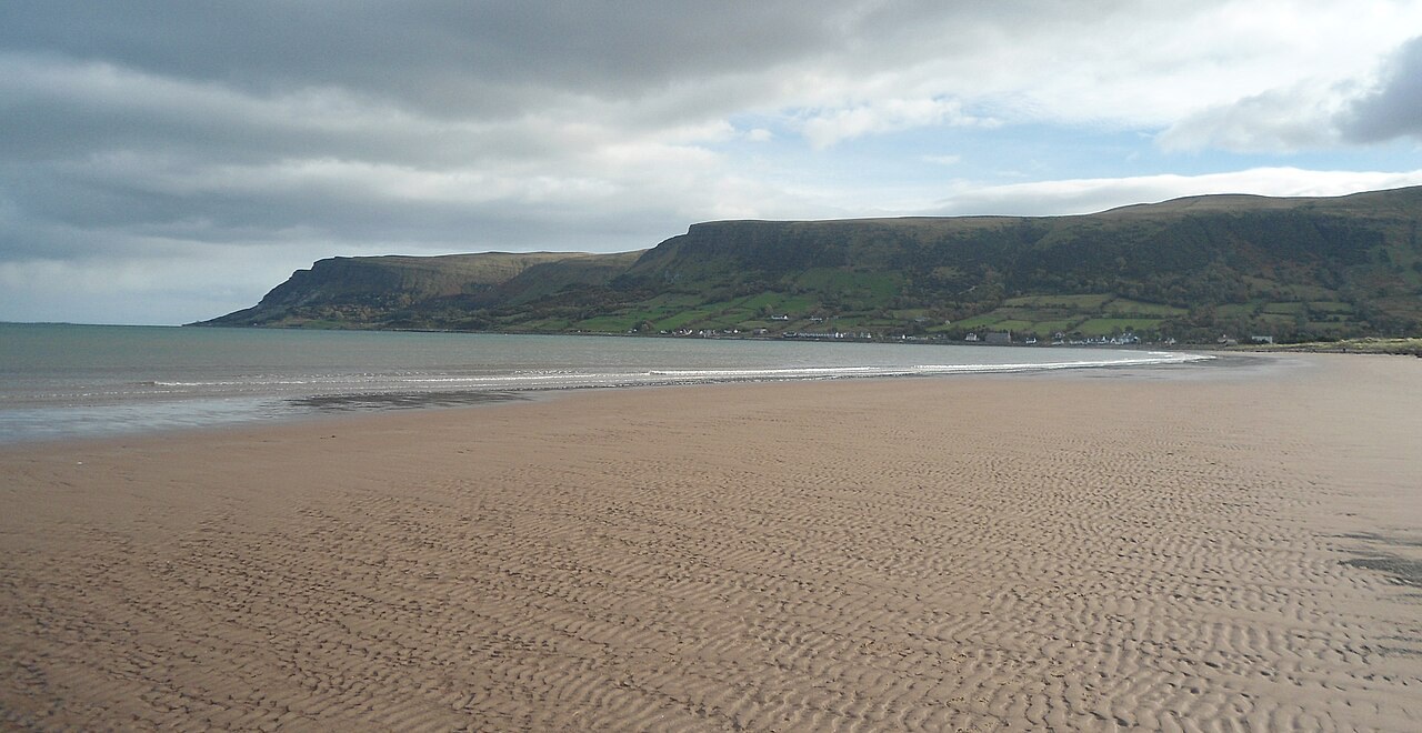
Red Bay at the foot of Glenariff
Waterfoot
A quiet sandy beach, river walks and a short Main Street at the coastal end of the Queen of the Glens.
- Best for
- Beach walks and Glenariff scenery
- Give it
- An afternoon, or longer with the forest park
- Know before
- The beach has no lifeguard service
Photo: Keith Ruffles · CC BY 3.0 · cropped
The Fox verdict
A quieter base where glen, river and bay meet
Waterfoot combines a roughly one-kilometre sandy beach with short local walks, modest Main Street stops and access to Glenariff scenery.
The strongest visit links the beach and its parkland with either the one-hour Glenariff River Walk or the marked waterfall and gorge trails at nearby Glenariff Forest Park. The sandstone Church of St Patrick and St Brigid adds mosaics, Michael Healy stained glass and an Ardclinis Crozier replica, while Red Bay Castle remains a roadside view because the ruin stands on private land.
Where to go
Places in Waterfoot
Every place below is checked against a published source, listed with what it is and how long to give it.
Local signatures
3 places
Start here
Waterfoot Beach
Sand backed by shallow dunes, coastal parkland, paths and picnic space, with clear-day views across Red Bay towards the Mull of Kintyre.
- Visit length
- Editorial estimate: 60 minutes
- Locality
- at the foot of Glenariff, where the Glenariff River reaches Red Bay
- Access
- There is no lifeguard service; winter cattle grazing restricts access to the conservation meadow.
Glenariff River Walk
An easy linear route following the Glenariff River, with Lurigethan to the north and the Garron Plateau to the south.
- Visit length
- Editorial estimate: About one hour
- Locality
- from Carnneill Park
- Access
- Riverbank footwear is advised.
Mariner's
A small, intimate traditional pub described by the official regional tourism site as a quiet-pint stop after a beach walk.
- Visit length
- Editorial estimate: 60 minutes
- Locality
- 7 Main Street, beside Waterfoot Beach
Food & drink
2 placesCostcutter Waterfoot
A village shop for household essentials, fresh food, produce, sweets, snacks and alcohol; the present scope of the separately recorded same-address butcher counter is not confirmed.
- Visit length
- Editorial estimate: 15 minutes
- Locality
- 21 Main Street
The Saffron Bar
A traditional village local classified by the Food Standards Agency as a pub/bar/nightclub, with a 2025 council report recording an indoor entertainments licence.
- Visit length
- Editorial estimate: 60 minutes
- Locality
- 4–6 Main Street
- Access
- No reliable current food menu was found; do not treat this as a meal stop.
Walks & outdoors
1 placeGlenariff Forest Park
Four marked routes range from the 0.6 km Rainbow Trail to the 8.9 km Scenic Trail; the 3 km waterfall walk uses cliff-cut paths and stilted boardwalks through a river gorge.
- Visit length
- Editorial estimate: 150 minutes
- Locality
- about 3.8 miles from Waterfoot Beach
History & heritage
3 placesChurch of St Patrick and St Brigid, Glenariffe
Completed in 1917 in local sandstone, with Ludwig Oppenheimer apse mosaics, three Michael Healy stained-glass windows and a replica of the 12th-century Ardclinis Crozier.
- Visit length
- Editorial estimate: 45 minutes
- Locality
- Glenariffe
Red Bay Castle
The surviving wall of a local-sandstone tower house stands on the headland; the castle was built in 1561, burned in 1565 and reduced to ruins by Cromwellian forces in 1652.
- Visit length
- Editorial estimate: 20 minutes
- Locality
- between Waterfoot and Cushendall
- Access
- The castle is on private land; this is a brief roadside viewpoint, not public access to the ruin.
Old Ardclinis Church
First documented in 1306 and recorded as decayed by 1622, the Scheduled Monument has one-metre-thick walls around a building footprint of about 18 m by 6.5 m and has been stabilised.
- Visit length
- Editorial estimate: 40 minutes
- Locality
- about two miles south
No places match this filter. Choose All places to reset the list.
Three ways to explore Waterfoot
Signature outings
Sand, dunes and long Red Bay views
Waterfoot's roughly one-kilometre beach is backed by shallow dunes and parkland, with the Mull of Kintyre visible across the bay in clear conditions.
Mosaics and Michael Healy glass
The 1917 sandstone church brings together Oppenheimer apse mosaics, three Michael Healy stained-glass windows and a replica of the medieval Ardclinis Crozier.
Boardwalks through waterfall country
Glenariff Forest Park's marked trails include a three-kilometre waterfall walk on cliff-cut paths and stilted boardwalks through the river gorge.
The village story
Waterfoot: where Glenariff reaches Red Bay
The locked seven-paragraph article moves from the beach and Main Street to the church, walks, ruins and practical transport.
Where the glen meets Red Bay
Main Street runs a short line of pubs, a chippy and a shop, and the sea is at the end of it. Waterfoot sits where the Glenariff River reaches Red Bay, at the foot of the glen that Antrim calls the Queen of the Glens, and the beach is a kilometre or so of sand backed by shallow dunes and a strip of parkland. On a clear evening you can see across the bay towards the Mull of Kintyre. The council gave the beach a Seaside Award in 2024, and it is one of the quieter stops on the Causeway Coastal Route, more used by locals for evening walks and summer picnics than by the coach traffic.
No. 9 Chippy & Café at 9 Main Street does fish and chips, onion rings, chicken goujons, southern-fried goujons and nuggets, and cooked breakfasts if you get there early enough. It has tables for eating in as well as a takeaway counter. A few doors along, the Costcutter at number 21 covers the rest: fresh food, produce, household basics, sweets and drink, with a butcher also listed at the same address.
Village pubs and Glenariffe's church
Two pubs share the street. Mariner's, at number 7, is a small traditional place next to the beach and works best as the quiet pint after a walk on the sand. The Saffron Bar, at 4–6 Main Street, is the village local; one visitor recorded the staff and regulars as very welcoming and a solo singer working the room, and the bar is licensed for indoor entertainment, so it is worth checking what's on.
The Church of St Patrick and St Brigid, up the road at Glenariffe, is worth the short detour inside. It was finished in 1917 in local sandstone quarried at Coskib, and, unusually for the date, the walls were built with a cavity. The apse carries mosaics by the Ludwig Oppenheimer workshop, including the four evangelists, and three stained-glass windows by Michael Healy show St Patrick preaching, the risen Christ at the Sea of Tiberias, and St Brigid handing out alms. Frank Rogers called them "three of the most delightful windows to be found anywhere in the Glens of Antrim." The porch holds a replica of the twelfth-century Ardclinis Crozier, the original of which is in the National Museum of Ireland. In the graveyard, four granite pillars mark the outline of an earlier church, St Killian's, dedicated in 1839 and burned by accident in 1915.
River, beach and forest walks
For walking, the Glenariff River Walk is the easy one: about three kilometres and an hour from Carnneill Park along the river to Greenaghan Cottage, with Lurigethan rising to the north and the Garron Plateau to the south; take footwear that copes with the riverbank. The Beach Walk from Main Street runs over mown grass, sand and boardwalk with views to the ruin of Red Bay Castle, past a wildflower meadow where yellow-rattle grows and small copper butterflies turn up, and two play parks, one with balance beams, a climbing net, a tunnel and a ball court. Longer legs can pick up the last section of the Moyle Way from Laragh Lodge, or drive the four miles up to Glenariff Forest Park for the waterfall and gorge trails.
Red Bay Castle and Carrivemurphy Pier
The castle itself, on a headland between here and Cushendall, is down to a single wall of its old tower house on private land, so it stays a thing you look at from the road. Sir James MacDonnell built it in 1561; Shane O'Neill burned it in 1565, Sorley Boy repaired it three years later, and Cromwellian forces finished it off in 1652. Nearer the shore, two concrete stumps are all that is left of Carrivemurphy Pier, built in 1874 for a mineral railway that carried iron ore down the glen and gave up after three years when the ore ran thin. The cormorants have it now, standing on the stumps with their wings out to dry.
The road in and summer evenings
Getting here means the A2 coast road; buses run Monday to Saturday on the 150 between Ballymena, the forest park, Waterfoot and Cushendall — check the current timetable, since there is nothing on a Sunday — and the nearest railhead is Ballymena, about 18.5 miles inland. On a summer evening the beach draws people who live here, out for a walk with the dog, and the light going long across the water towards Scotland.
Stay around Causeway Coast
Make a longer stay of it
Travel Fox holiday homes around Causeway Coast, linked directly to their property pages.
For homeowners
Own a holiday home near Waterfoot?
We manage holiday lets across the UK from 12% commission, charged after cleaning costs, with no lock-in. A co-founder visits before you decide.
How our holiday let management works →
A guide with a point of view
Written from research. Edited for real journeys.
Use the Official site links for live practical details, then use this guide for context, ideas and room to explore.
Photography credits & licences
Third-party photographs are credited to their named creators and reused under the linked Creative Commons licence or public-domain dedication. Travel Fox stores an optimised local copy; the file-specific changes and any browser-applied display crop are disclosed below. Reused photographs link both to the Wikimedia Commons source record and to the declared source image; Travel Fox's own photographs carry no such record and are marked as ours. These image licences do not cover Travel Fox text, branding or page design.
- File:The beach at Waterfoot - panoramio.jpg — photograph by Keith Ruffles; Keith Ruffles. Source record on Wikimedia Commons. Declared source image. Licence: CC BY 3.0. File changes: Downloaded from Wikimedia Commons, resized to a maximum 1920px edge and encoded as an optimised JPEG. Display changes: Displayed with responsive CSS cropping.
Sources
Every place on this page is checked against a published source. Each entry links the record we used and names who publishes it.
- Waterfoot Beach — causewaycoastandglens.gov.uk statutory register or public authority
- Glenariff River Walk — visitcausewaycoastandglens.com operator, sector body or destination organisation
- Glenariff Forest Park — nidirect.gov.uk statutory register or public authority
- Church of St Patrick and St Brigid, Glenariffe — aims.niassembly.gov.uk statutory register or public authority
- Costcutter Waterfoot — store-locator.costcutter.co.uk operator, sector body or destination organisation
- Mariner's — visitcausewaycoastandglens.com operator, sector body or destination organisation
- The Saffron Bar — ratings.food.gov.uk statutory register or public authority
- Red Bay Castle — visitcausewaycoastandglens.com operator, sector body or destination organisation
- Old Ardclinis Church — antrimhistory.net other published source