
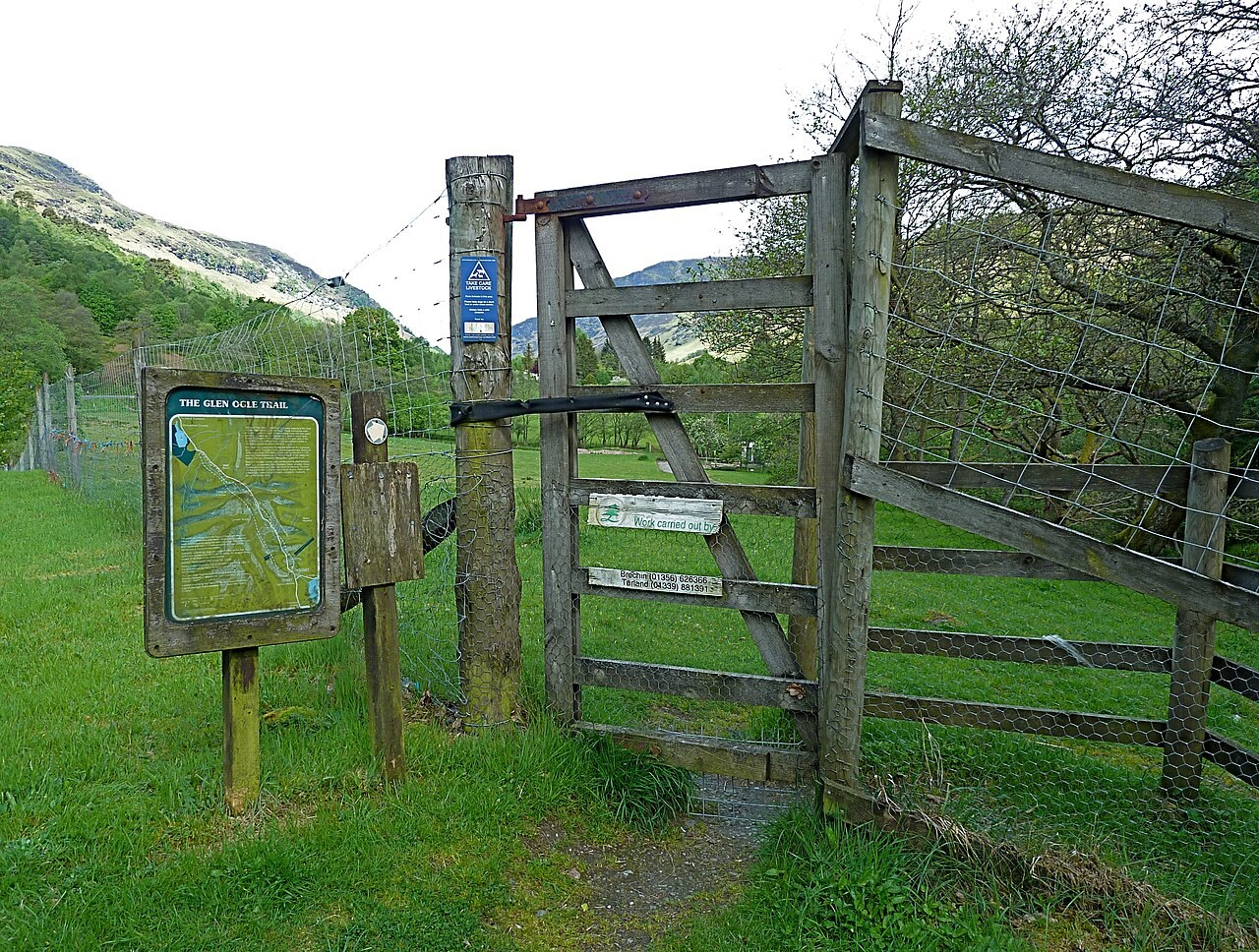
Loch, glen and old railway
Lochearnhead
A small base at Loch Earn's western end for watersports, a viaduct walk and layers of local railway and church history.
- Best for
- Walking and Loch Earn recreation
- Main walk
- Glen Ogle Trail: 6.5 miles, 3–4 hours
- Know now
- There are no shops in the village
Photo: Anthony O'Neil · CC BY-SA 2.0 · cropped
The Fox verdict
A lochside base built around the outdoors
Lochearnhead pairs coached and self-hire activities on Loch Earn with a railway-line walk into Glen Ogle.
The village's strongest reasons to stop are specific: the Glen Ogle Trail reaches the viaduct along the dismantled railway, Loch Earn Wakeschool gets visitors onto the water, and St Angus's adds compact historical interest. The Clachan provides lochside food and can prepare packed lunches.
Where to go
Places in Lochearnhead
Every place below is checked against a published source, listed with what it is and how long to give it.
Local signatures
3 placesThe Clachan Hotel
A relaxed hotel restaurant and separate bar in whitewashed cottages, serving hearty seasonal cooking with loch views; the restaurant can prepare packed lunches.
- Visit length
- Editorial estimate: around 90 minutes
- Locality
- lochside
Loch Earn Wakeschool
Coached wakeboarding, wakesurfing and waterskiing are offered alongside ringo rides, scenic boat trips, and self-hire paddleboards and kayaks.
- Visit length
- Editorial estimate: around 2 hours
- Locality
- beside the Clachan
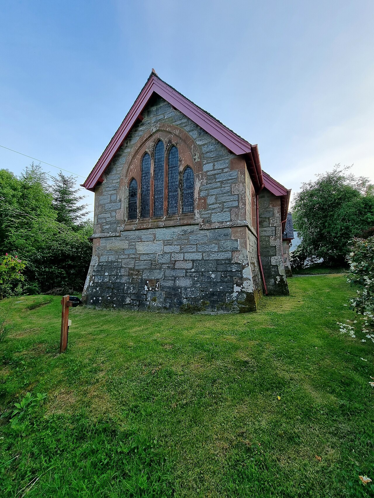
St Angus's Episcopal Church
A circa-1885 plain Gothic church with a top-heavy gabletted belfry, an 1890 Dublin-cast bell, leaded glass and a painted-and-gilded reredos.
- Visit length
- Editorial estimate: around 30 minutes
- Locality
- Lochearnhead
- Access
- Services vary.
Walks & outdoors
2 places
Glen Ogle Trail
A steep climb reaches the dismantled railway, then a good cycle path leads to Glen Ogle Viaduct with views back over Lochearnhead and autumn colour along the old line.
- Visit length
- Editorial estimate: 3–4 hours
- Locality
- Glen Ogle
- Access
- The return near the old military road is very boggy, overgrown and navigation-heavy; walkers can retrace the railway instead.
Falls of Dochart
At Killin, the River Dochart spreads into broad rocky rapids beneath the bridge.
- Visit length
- Editorial estimate: around 45 minutes
- Locality
- Killin
History & heritage
1 placeRob Roy MacGregor's Grave
Rob Roy MacGregor's grave is in the kirkyard at Balquhidder; he lived locally and died at Inverlochlarig Beg in 1734.
- Visit length
- Editorial estimate: around 30 minutes
- Locality
- Balquhidder
No places match this filter. Choose All places to reset the list.
Three ways to explore Lochearnhead
Signature outings
Glen Ogle Viaduct
Climb to the dismantled railway and follow the cycle path to the viaduct for views back over Lochearnhead; retracing the railway avoids the boggy, navigation-heavy return.
St Angus's Church
The top-heavy belfry, Dublin-cast bell, leaded windows and painted-and-gilded reredos give this plain Gothic church its character.
Falls of Dochart
About fourteen minutes from Lochearnhead, the River Dochart spreads into broad rocky rapids beneath Killin's bridge.
The village story
Lochearnhead Village Guide
Lochside food, water recreation, an old railway walk and Highland history.
Lochside Food and the Lost Shop
At The Clachan Hotel, the bar looks across Loch Earn to Edinample Castle, a late sixteenth-century tower house on the far shore. The hotel occupies a lochside row of whitewashed cottages. Its seasonal menus have included beer-battered haddock, steak and Guinness pie, Campbell's haggis with neeps, tatties and whisky cream, three-cheese macaroni, Highlander chicken stuffed with haggis, and beer-battered halloumi. The bar has offered a changing cask beer in summer, often from Belhaven. The restaurant can prepare a packed lunch.
There are no shops in Lochearnhead. The last one, a post office and store built around 1870, closed around 2023 and is now a house called Taigh Na Bhuth; by the 1970s its front garden had spent time as an Esso forecourt. Provisions are available in Killin, a fourteen-minute drive, or in Callander farther south.
Water, Railways and Hill Paths
The village sits where the A84 meets the A85, at the western end of the loch and the foot of Glen Ogle, with the Breadalbane hills rising behind. Loch Earn has a seiche, a wind-driven tide of sorts that lifts the water at one end. Beside the village's lochside hotel, Loch Earn Wakeschool runs coached wakeboarding, wakesurfing and waterskiing, along with ringo rides, scenic boat trips, and self-hire paddleboards and kayaks.
Walking is the main draw here. The Glen Ogle Trail is a six-and-a-half-mile circuit that climbs steeply to a dismantled railway, follows a good cycle path to the Glen Ogle Viaduct and looks back down over the village, with autumn colour along the old line. The return, near the military road, is boggy and overgrown enough that retracing the railway is the easier option. This is the ground where, in 2004, landslides trapped fifty-seven motorists between two slips; everyone was airlifted out over three hours and no one was hurt. The long-distance Rob Roy Way passes through on its way from Drymen to Pitlochry, and National Cycle Route 7 shares the old railway line. South of the loch, Ben Vorlich rises to a pyramid point at 985 metres, usually climbed from Ardvorlich rather than from here.
Inside St Angus's Church
St Angus's Episcopal Church, built around 1885 in plain Gothic, has a deliberately top-heavy belfry and a bell cast in Dublin in 1890. Inside are clear leaded windows with coloured margins, an east window remembering Rear Admiral Malcolm MacGregor, and a painted and gilded reredos showing Saints Ninian, Columba, Blane and Angus.
Highland Games
The Balquhidder, Lochearnhead and Strathyre Highland Games were revived by Ewen Cameron, a six-foot-five, twenty-two-stone hotelier who once won more than a hundred first prizes in a single season and took his caber to perform before thirty thousand people in Denmark. The Ewen Cameron Cup honours the best all-round thrower of ball, hammer and caber.
Killin, Balquhidder and the Wider Base
Lochearnhead is a base for walks and short drives. In Killin, the River Dochart spreads into broad rocky rapids beneath the bridge. West of the A84, Rob Roy MacGregor’s grave is in Balquhidder kirkyard; he died at Inverlochlarig Beg farther up the glen in 1734.
Stay around Loch Lomond
Make a longer stay of it
Travel Fox holiday homes around Loch Lomond, linked directly to their property pages.
For homeowners
Own a holiday home near Lochearnhead?
We manage holiday lets across the UK from 12% commission, charged after cleaning costs, with no lock-in. A co-founder visits before you decide.
How our holiday let management works →
A guide with a point of view
Written from research. Edited for real journeys.
Use the Official site links for live practical details, then use this guide for context, ideas and room to explore.
Photography credits & licences
Third-party photographs are credited to their named creators and reused under the linked Creative Commons licence or public-domain dedication. Travel Fox stores an optimised local copy; the file-specific changes and any browser-applied display crop are disclosed below. Reused photographs link both to the Wikimedia Commons source record and to the declared source image; Travel Fox's own photographs carry no such record and are marked as ours. These image licences do not cover Travel Fox text, branding or page design.
- File:Start of the Glen Ogle Trail near Lochearnhead - geograph.org.uk - 2426711.jpg — photograph by Anthony O'Neil; Start of the Glen Ogle Trail near Lochearnhead by Anthony O'Neil. Source record on Wikimedia Commons. Declared source image. Licence: CC BY-SA 2.0. File changes: Downloaded from Wikimedia Commons, resized to a maximum 1920px edge and encoded as an optimised JPEG. Display changes: Displayed with responsive CSS cropping.
- File:St Angus's Scottish Episcopal Church, Lochearnhead 02.jpg — photograph by Auldcathy; Own work. Source record on Wikimedia Commons. Declared source image. Licence: CC BY-SA 4.0. File changes: Downloaded from Wikimedia Commons, resized to a maximum 1920px edge and encoded as an optimised JPEG. Display changes: Displayed with responsive CSS cropping.
Sources
Every place on this page is checked against a published source. Each entry links the record we used and names who publishes it.
- The Clachan Hotel — clachanhotel.co.uk operator, sector body or destination organisation
- Loch Earn Wakeschool — lochearnwakeschool.co.uk operator, sector body or destination organisation
- Glen Ogle Trail — walkhighlands.co.uk other published source
- St Angus's Episcopal Church — portal.historicenvironment.scot statutory register or public authority
- Falls of Dochart — lochlomond-trossachs.org other published source
- Rob Roy MacGregor's Grave — lochlomond-trossachs.org other published source