
Black Mountains valley
Llangenny
A fast river, a late-medieval church, a stone packhorse bridge and a direct climb onto Sugar Loaf.
- Best for
- Mountain walking, church detail and independent food shopping
- Give it
- A moderate-to-hard 6½-mile Sugar Loaf circuit
- Don't miss
- The Norman font and the hump-backed packhorse bridge
Photo: Jonathan Thacker · CC BY-SA 2.0 · cropped
The Fox verdict
A small valley base with a mountain on the doorstep
Llangenny brings together a documented Sugar Loaf circuit, a richly detailed late-medieval church and the Grwyne Fawr's stone bridges.
The village itself has no shop, so the most useful visit pairs its church, riverside history and mountain walking with Crickhowell's independent food shops about 2 km west. Tretower Court and Castle adds a Norman tower, restored medieval court and furnished great hall nearby.
Where to go
Places in Llangenny
Every place below is checked against a published source, listed with what it is and how long to give it.
Local signatures
3 placesNatural Weigh
A zero-waste shop selling organic wholefoods, artisan bread, bakery items and refills; it identifies itself as Wales's first zero-waste shop, opened in 2018.
- Visit length
- Editorial estimate: Allow around 30 minutes
- Locality
- Crickhowell
MT Cashell & Sons
A family butcher and delicatessen selling local produce, handcrafted cheeses, pâtés, pies and cooked meats.
- Visit length
- Editorial estimate: Allow around 30 minutes
- Locality
- Crickhowell
Tretower Court and Castle
A Cadw site combining a Norman castle tower, restored medieval court, furnished great hall, 15th-century garden and picnic facilities.
- Visit length
- Editorial estimate: Allow around 90 minutes
- Locality
- three miles north-west of Crickhowell
History & heritage
2 places
Church of St Cenau
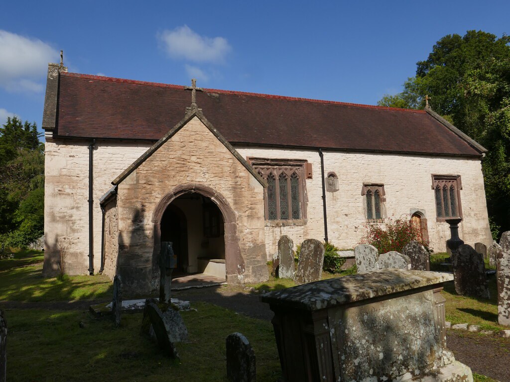
A Grade II* late-medieval church with a cable-moulded Norman font, wagon roofs, small squints, a Tudor-headed priest's door and a short screen with pierced tracery.
- Visit length
- Editorial estimate: Allow around 45 minutes
- Locality
- close to the Grwyne Fawr
Llangenny Packhorse Bridge
A Grade II single-span hump-backed rubble-sandstone bridge over the Grwyne Fawr, already shown on the 1839 tithe map.
- Visit length
- Editorial estimate: Allow around 30 minutes
- Locality
- about 0.8 km north-north-west of the church
No places match this filter. Choose All places to reset the list.
Three ways to explore Llangenny
Signature outings
Find the hump-backed bridge
A footpath north of St Cenau's Church reaches this Grade II single-span rubble-sandstone bridge over the Grwyne Fawr, shown on the 1839 tithe map.
Find the Norman font
Inside St Cenau's late-medieval church, the cable-moulded round font is the sole survival from the earlier Norman church on the site.
Pair tower and court
Tretower brings together a Norman castle tower, a restored medieval court, a furnished great hall and a 15th-century garden.
The village story
Llangenny Village Guide
A small community folded into the Grwyne Fawr valley beneath the Black Mountains.
The Dragons Head and Sugar Loaf
The Dragons Head sits beside Llangenny Bridge, where the Grwyne Fawr comes down fast off the Black Mountains. It is a country pub of the unfussy sort: a real fire, a garden, parking, and a bar that keeps Rhymney Hobby Horse session bitter on as the regular ale alongside a couple of changing guests. The food is plain and short: dishes have included garlic chicken, ham, egg and chips, onion rings, and a vegetarian roast at Sunday lunch.
The pub is the start and finish of a six-and-a-half-mile circuit onto the mountain: a wet green lane, the Cwm-cegyr track, then open hillside to a rocky summit trig point with the Black Mountains, Ysgyryd Fawr and the hills of the South Wales valleys laid out around it. The descent drops through fields and picks up the Grwyne Fawr back into the village. It is graded moderate to hard, and the lanes are working ones—leave room for residents and the tractors.
Shopping and St Cenau's Church
There is no shop in Llangenny, and none anywhere in the Vale of Grwyney. What the community has instead is a pub apiece across three small settlements, and Crickhowell two kilometres west. The town carries the food shopping. Grenfell & Sons is the family grocer; MT Cashell & Sons handles meat, handcrafted cheeses, pâtés, pies and cooked meats; Natural Weigh, which opened in 2018 as Wales's first zero-waste shop, sells organic wholefoods, artisan bread and refills. Crickhowell Bakery is on the High Street.
St Cenau's church stands close to the water, late-medieval, listed Grade II*. The round Norman font, carved with cable moulding, is the only survival from the earlier church on the site. Inside there are wagon roofs, small squints, a Tudor-headed priest's door and a short screen with pierced tracery, and on the wall a 1688 tablet to Lewis Morgan carrying a nag's-head crest. Charles Buckeridge restored the building in 1863, and it was worked on again in 1894.
Bridge, Spring and Valley Work
A footpath running north of the church reaches a single-span humpbacked packhorse bridge over the Grwyne Fawr, one of a run of stone bridges along these rivers and already drawn on the tithe map of 1839.
The village takes its name from Cenau, a saint whose spring, Ffynnon Ceneu, rises in woodland across the river. An oratory said to have stood there was pulled down in 1790, and an early-medieval iron bell turned up in the demolition; it is now held by National Museum Wales. For a long stretch the valley worked for its living—watermills grinding grain and fulling wool, an iron forge down near the Usk, and paper-making that carried on until 1950.
A Village Folded into the Valley
The settlement has spread up the valley sides mostly within the last 150 years; the historic core is small, and the whole community lies inside the Brecon Beacons National Park, with the Grwyne Fawr marking part of the boundary between Powys and Monmouthshire. You reach it by minor lanes signposted off the A40 between Abergavenny and Crickhowell, and the nearest station is Abergavenny, about six miles away on the Welsh Marches Line.
Christopher Somerville came down off the mountain into Llangenny after rain and wrote that "all seemed right with the little world folded into its valley in the eastern skirts of the mountains."
Stay around Brecon Beacons
Make a longer stay of it
Travel Fox holiday homes around Brecon Beacons, linked directly to their property pages.
For homeowners
Own a holiday home near Llangenny?
We manage holiday lets across the UK from 12% commission, charged after cleaning costs, with no lock-in. A co-founder visits before you decide.
How our holiday let management works →
A guide with a point of view
Written from research. Edited for real journeys.
Use the Official site links for live practical details, then use this guide for context, ideas and room to explore.
Photography credits & licences
Third-party photographs are credited to their named creators and reused under the linked Creative Commons licence or public-domain dedication. Travel Fox stores an optimised local copy; the file-specific changes and any browser-applied display crop are disclosed below. Reused photographs link both to the Wikimedia Commons source record and to the declared source image; Travel Fox's own photographs carry no such record and are marked as ours. These image licences do not cover Travel Fox text, branding or page design.
- File:Church of St Cenau, Llangenny - geograph.org.uk - 7883297.jpg — photograph by Jonathan Thacker; Church of St Cenau, Llangenny by Jonathan Thacker. Source record on Wikimedia Commons. Declared source image. Licence: CC BY-SA 2.0. File changes: Downloaded from Wikimedia Commons, resized to a maximum 1920px edge and encoded as an optimised JPEG. Display changes: Displayed with responsive CSS cropping.
Sources
Every place on this page is checked against a published source. Each entry links the record we used and names who publishes it.
- Church of St Cenau — cadwpublic-api.azurewebsites.net other published source
- Llangenny Packhorse Bridge — cadwpublic-api.azurewebsites.net other published source
- Natural Weigh — visitcrickhowell.wales operator, sector body or destination organisation
- MT Cashell & Sons — visitcrickhowell.wales operator, sector body or destination organisation
- Tretower Court and Castle — cadw.gov.wales statutory register or public authority