
Kingussie, Badenoch
Kingussie
A planned Highland town where short woodland paths, a living shinty ground and the Spey floodplain sit alongside a well-provisioned High Street.
- Short walk
- The Gynack Mill Trail is a roughly one-hour circuit.
- Low-level history
- The Speyside Way reaches Ruthven Barracks in about one mile.
- Public transport
- Kingussie has Highland Main Line trains and Stagecoach 39/M39 buses.
Photo: Euan Nelson · CC BY-SA 2.0 · cropped
The Fox verdict
Come for a town that opens directly into burn, hill and floodplain
Kingussie's strength is the range available from the town itself: an easy pond circuit, the wooded Gynack trail, Creag Bheag, Ruthven Barracks and the Insh Marshes landscape.
The High Street remains useful as well as characterful, with an independent butcher, current hotel bars and small shops, while the Dell keeps shinty at the centre of civic life. The accepted article's best route is outward from town to Ruthven and the Spey floodplain, with the shorter paths and food stops used according to time and conditions.
Where to go
Places in Kingussie
Every place below is checked against a published source, listed with what it is and how long to give it.
Local signatures
3 placesRuthven Barracks
The roofless barracks occupy a strategic mound above the Spey on the site of earlier Comyn and Gordon castles. Jacobite forces gathered here after Culloden before dispersing and burning the barracks.
- Visit length
- Editorial estimate: Allow about 1 hour
- Locality
- On the mound south of the River Spey
RSPB Insh Marshes
A 10-square-kilometre Spey floodplain reserve of pools and marsh views, where curlew, lapwing, redshank and snipe breed.
- Visit length
- Editorial estimate: Allow about 1 1/2 hours
- Locality
- East of Ruthven
D. Gilmour Butchers
A family butcher emphasising locally sourced meat, especially lamb and mutton, with its own sausages, bacon, haggis, puddings and pies alongside seasonal vegetables and selected cheeses.
- Visit length
- Editorial estimate: Allow about 20 minutes
- Locality
- High Street
Food & drink
1 placeGhillies Rest Lounge Bar
A refurbished lounge bar expressly open to non-residents, offering bar meals, Highland malts and gins, and bottled and draught local beers in a former eighteenth-century stagecoach stop.
- Visit length
- Editorial estimate: Allow about 1 1/4 hours for a drink and bar meal
- Locality
- Newtonmore Road
- Access
- CAMRA records family access, a garden and step-free access to the lounge bar.
Walks & outdoors
1 placeGynack Mill Trail
A signed circuit beside the Gynack Burn, using smooth gravel in places and including steps. It links water, hazel woodland and the burn that once powered the town.
- Visit length
- Editorial estimate: About 1 hour
- Locality
- Beside the Gynack Burn through hazel woodland
- Access
- The signed route uses smooth gravel in places but includes steps.
Things to do
1 place
The Dell
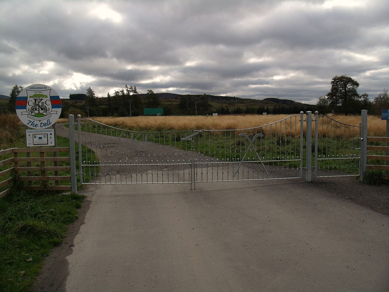
The home ground of Kingussie Camanachd Club, formed in 1890 and winner of the first Camanachd Cup in 1896. On a match day it is where the town's living shinty tradition is most visible.
- Visit length
- Editorial estimate: Allow about 1 hour when a match is taking place
- Locality
- Kingussie
No places match this filter. Choose All places to reset the list.
Three ways to explore Kingussie
Signature outings
Ghillies Rest carries Kingussie's coaching past
Set in a former eighteenth-century stagecoach stop, this refurbished lounge pairs its historic setting with bar meals, Highland malts and gins, and local beer.
Insh Marshes gives the valley its scale
Beyond Ruthven, pools, breeding waders and roughly ten square kilometres of floodplain open out across the Spey strath.
The Dell keeps shinty in the present tense
Kingussie Camanachd Club's home is an active civic space, not simply a memorial to the club that won the first Camanachd Cup.
The town story
Kingussie: burn, barracks and the broad Spey strath
The locked article moves from a working High Street through the town's bars, shops and short paths to Ruthven, Insh Marshes and the shinty ground at the Dell.
A butcher sets the tone
The butcher on the High Street, D. Gilmour, still sells mutton alongside the lamb. The family shop runs to Highland game, its own sausages, bacon, haggis and puddings, pies, steak and offal, with a counter of seasonal vegetables and selected cheeses at the front. A working butcher of that range, in a Highland town of a few thousand people, tells you most of what you need to know about how well the place is provisioned.
Kingussie sits in the upper Spey strath, the Monadhliath rising immediately to the north and west, the Cairngorms across the valley to the east, and the Drumochter Pass closing the strath to the south-west. The Gynack Burn comes down off the hill and runs through the town to the river. Above it stand Creag Bheag and Loch Gynack; below it, across the Spey, the roofless shell of Ruthven Barracks stands on its mound. The Gaelic name, Ceann a' Ghiùthsaich, means head of the pine forest, and the older settlement grew up not here but at Ruthven, where the routes through Drumochter, Glen Truim and Glen Feshie met at a ford. The present town is a planned one, laid out in the late eighteenth century once a bridge had been built at Ralia.
The railway arrived in 1863 and helped shape the modern town. Trains still stop at a station substantially of 1894, built for the Highland Railway by William Roberts, with later additions that once included staff dormitories and rooms set aside for making up luncheon baskets. There are ten cycle stands, a ticket office and toilets, and the Highland Main Line runs north to Inverness and south to Perth, Edinburgh and Glasgow. Kingussie is also a stop on the Caledonian Sleeper, so you can arrive from London overnight, if the dates line up. By road it lies just off the A9, with the A86 forming the main through street toward Newtonmore and the B970 crossing the Spey toward Ruthven and Insh; the Stagecoach 39 and M39 buses link the town along the corridor to Newtonmore, Kincraig and Aviemore.
Strath, burn and railway
For a drink and a meal there are three current options: the Duke of Gordon, the Star and the golf clubhouse. The Duke of Gordon Hotel on Newtonmore Road keeps the Ghillies Rest, a refurbished lounge bar expressly open to non-residents, with bar meals, Highland malts and gins, and bottled and draught local beer. The cask ales, when surveyed, ran to Cairngorm Trade Winds, Stag and Wildcat; there is a real fire, family access, step-free entry to the lounge and a garden. The building began as an eighteenth-century stagecoach stop on the old A9, and it is the most historically legible of the current town bars. It has long hosted international Clan Macpherson gatherings, and the Balmoral Restaurant retains its corniced ceilings and original murals by an artist named Peddie.
The Star Hotel, on the High Street, has divided itself into two rooms with different tempers. The Wolf Bar is the informal one, a modern Highland and sports bar with screens and darts, doing haggis bon-bons with clapshot and peppercorn sauce, haddock in local-ale batter, a pie of the day, a Scottish Wagyu burger, macaroni cheese, and sticky toffee pudding with Arran vanilla ice cream. Next door the Jacobite Bar and Grill is the more composed room, modern Scottish cooking on local seasonal produce: grilled goat's cheese salad with beetroot and walnuts, porcini mushroom arancini, a salmon fillet with new potatoes, green beans and caper-and-garlic butter, butternut-squash risotto, a Highland cheese board, lemon posset. Both do a version of the sticky toffee pudding, and between them they offer both a match on the television and a sit-down dinner, without your having to leave the building.
The third is the golf clubhouse, which admits visitors to what it calls the nineteenth hole. It overlooks the first tee and the close of the eighteenth, with outdoor seating by the putting green and long views toward the Cairngorms. There is one handpump, usually Cairngorm Trade Winds in summer, pool inside and trestle tables out. Golf has been played here since 1890, and Old Tom Morris was invited in 1895 to advise on the course; the nine-hole layout that Captain MacHardy laid out reportedly cost eight pounds, the golfers were briefly ejected after a dispute, and the core of the 1911 clubhouse still stands.
Bars, tables and High Street life
The rest of the eating is spread along and off the High Street. Joe's is the chippy on the corner and does the ordinary miracle of clean oil and good batter. Royal Tandoori, at 68 to 70 High Street, does chicken tikka, lamb biryani and house specialities; there is a Chinese takeaway further along at number 49. For daytime, the Railway Cafe sits not on the High Street at all but in the industrial estate, pouring Vandyke Brothers coffee and turning out hot filled rolls with bacon, black pudding, Lorne sausage, egg or a tattie scone, alongside soup, sandwiches, filled ciabatta and cakes. The Sugar Bowl combines a cafe with a gift shop and runs to breakfast rolls, BLTs, panini and caramel shortcake. Cafe Bistro is the one to book: it has only a few tables, and diners come away talking about scallops on black pudding, venison with plum sauce, and profiteroles with a hot toffee and whisky-and-black-pepper ice cream. The scarcity of seats is the more useful thing to know than any star rating.
The High Street also carries a run of galleries and small shops. The Iona Gallery, run by the Society of Badenoch and Strathspey Artists, is the only dedicated public art gallery in the Cairngorms National Park; Eleven41 at number 35 shows photography; Chapel House Arts brings together Anne Bridgen's fused glass with Kirsty Ritchie's paintings. Aladdins Other Cave at number 39 sells antiques, gifts and collectables, and Caberfeidh Horizons, a social enterprise, runs a bookshop and a second charity shop with a community food-share. Bothy Bikes handles sales, repairs and the kind of local riding knowledge worth having before you set out. The Co-op at number 24 covers the ordinary shopping, with a bakery and food-to-go, and the Post Office is now at number 26.
The walking begins within the town itself, which is the strength of the place. The Glebe Ponds circuit is half a kilometre of flat path, with a boardwalk through a small birch wood, gates, picnic tables and passing trains, laid out for wheelchairs and buggies. The Gynack Mill Trail is a little over a mile along the burn through hazel woodland, mostly smooth gravel with some steps, and puts the water that once powered the town within an easy hour. For a hill, Creag Bheag is a waymarked circuit of four and a half miles that climbs through regenerating birch and pine into open heather, with red squirrels below and the crags used by climbers above, and a view from the top across the town to the Cairngorms, Loch Gynack and the Monadhliath. The descent is steep and rocky, so leave time for it. Longer routes run over the moor to Newtonmore by the Curlew Trail or the Loch Gynack path, passing the remains of old townships on the way.
Paths to Ruthven and the marshes
A strong low-level option crosses the Spey. The Speyside Way reaches Ruthven Barracks in about a mile, and the whole story of the town's two defining subjects, Jacobite history and the Spey floodplain, opens up from the mound. George I's government built the barracks between 1719 and 1721 after the 1715 rising, on a site that had already carried medieval Comyn and Gordon castles; only a well survives from the older fortifications. It held about a hundred and twenty men in two three-storey blocks, each room housing ten, two men to a bed, with a guardroom, prison, bakehouse and brewhouse in the compound and, after 1734, General Wade's stables for thirty horses. In August 1745 some three hundred Jacobites attacked the twelve redcoats holding it and failed to take it; the defending sergeant reported that his sole fatality died, in his phrase, by foolishly holding his head high over the parapet. The garrison surrendered the following February. Then, after Culloden on 16 April 1746, the Jacobite remnants gathered here, and on the twentieth Charles Edward Stuart sent the instruction "Let every man seek his own safety in the best way he can." The men dispersed and the barracks were burned, and it is the roofless shell of that burning that dominates the approach today.
Beyond the barracks the ground opens into Insh Marshes, roughly ten square kilometres of Spey floodplain where curlew, lapwing, redshank and snipe breed among the pools; the RSPB is undoing old drainage and grazing the land with sheep, cattle and ponies to bring back a wilder floodplain. From Ruthven the old ford, the Jacobite ending and the marshes fall into a single view.
Memory, graves and shinty
Kingussie carries its own quieter histories too. James Macpherson, the poet and controversial translator of the Ossian poems, was born at Ruthven in 1736. Robert Louis Stevenson spent a fortnight here in the summer of 1882, working on a story and writing to a friend, "I think I'll send all my friends to Kingussie." Isobel Grant opened the Highland Folk Museum here in 1944, the first open-air museum on the British mainland, before it moved down the strath to Newtonmore, where it still runs. And in the New Cemetery lie nine graves of the Force K6, Royal Indian Army Service Corps men who trained with their mules in the Cairngorms during the Second World War; a memorial in Gynack Gardens names fourteen of them, thirteen Muslim and one Hindu. Isobel Harling tended those nine graves for more than seventy years.
For all of that, one of the things the town seems proudest of is shinty. Kingussie Camanachd Club formed in 1890, won the first Camanachd Cup in 1896, and once went sixty-three matches without losing; five of its 1914 team were killed in the First World War. The Dell, where the club plays, is still one of the town's working civic spaces rather than a monument, and on a match day it is the obvious place to see the town gathered. Whatever else has come and gone along the High Street, the red-and-blue hoops have been turning out since 1890.
Stay around Cairngorms
Make a longer stay of it
Travel Fox holiday homes around Cairngorms, linked directly to their property pages.
For homeowners
Own a holiday home near Kingussie?
We manage holiday lets across the UK from 12% commission, charged after cleaning costs, with no lock-in. A co-founder visits before you decide.
How our holiday let management works →
A guide with a point of view
Written from research. Edited for real journeys.
Use the Official site links for live practical details, then use this guide for context, ideas and room to explore.
Photography credits & licences
Third-party photographs are credited to their named creators and reused under the linked Creative Commons licence or public-domain dedication. Travel Fox stores an optimised local copy; the file-specific changes and any browser-applied display crop are disclosed below. Reused photographs link both to the Wikimedia Commons source record and to the declared source image; Travel Fox's own photographs carry no such record and are marked as ours. These image licences do not cover Travel Fox text, branding or page design.
- File:The Dell, Kingussie - geograph.org.uk - 2646484.jpg — photograph by Euan Nelson; The Dell, Kingussie by Euan Nelson. Source record on Wikimedia Commons. Declared source image. Licence: CC BY-SA 2.0. File changes: Downloaded from Wikimedia Commons, resized to a maximum 1920px edge and encoded as an optimised JPEG. Display changes: Displayed with responsive CSS cropping.
Sources
Every place on this page is checked against a published source. Each entry links the record we used and names who publishes it.
- Gynack Mill Trail — cairngorms.co.uk other published source
- Ruthven Barracks — historicenvironment.scot statutory register or public authority record not machine-readable; publisher restricts automated access
- RSPB Insh Marshes — rspb.org.uk national body or asset manager
- D. Gilmour Butchers — dgilmourbutchers.com operator, sector body or destination organisation
- Ghillies Rest Lounge Bar — dukeofgordonhotel.co.uk other published source
- The Dell — kingussiecamanachdclub.co.uk other published source