
Canal, hills and history
Kilsyth
A town where a pedestrianised main street, canal towpath, public parks and steep hills meet Roman and Civil War history.
- Best for
- Canal walking, town parks and layered history
- Give it
- A day split between Kilsyth and its nearby heritage landscapes
- Don't miss
- Colzium's walled garden, glen, ice house and curling ponds
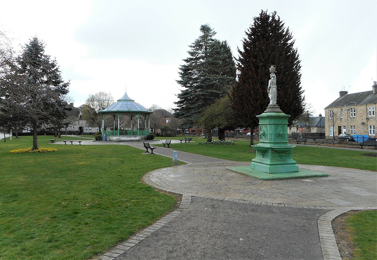
Photo: Richard Sutcliffe · CC BY-SA 2.0 · cropped
The Fox verdict
A small town with routes into several eras
Kilsyth combines a pedestrianised centre with canal walking, public parks, upland country and unusually visible layers of Roman and Civil War history.
The Forth and Clyde Canal provides level walking and cycling from Auchinstarry, while the land rises steeply into the Kilsyth Hills immediately north of town. Colzium brings together a walled garden, arboretum, glen, ice house, curling ponds and playground; nearby landscapes hold the Battle of Kilsyth and the Antonine Wall's Bar Hill fort.
Where to go
Places in Kilsyth
Every place below is checked against a published source, listed with what it is and how long to give it.
Local signatures
3 placesColzium Estate
A public park with a walled garden, arboretum, glen, children's playground, historic ice house and curling ponds.
- Visit length
- Editorial estimate: allow around 90 minutes
- Locality
- northeast of the centre
Forth and Clyde Canal Towpath
Level walking and cycling from Auchinstarry towards Twechar and Kirkintilloch, on a canal section also followed by the John Muir Way.
- Visit length
- Editorial estimate: allow around 90 minutes
- Locality
- from Auchinstarry Marina
Bar Hill Fort
The highest fort on the Antonine Wall, with visible remains of its headquarters building, bathhouse and a 43-foot-deep well.
- Visit length
- Editorial estimate: allow around 75 minutes
- Locality
- above nearby Twechar
Food & drink
1 placeThe Boat House
A canalside pub and restaurant with outdoor seating, used as a stop by boaters, walkers and cyclists on the towpath.
- Visit length
- Editorial estimate: allow around 90 minutes
- Locality
- Auchinstarry Marina
Walks & outdoors
1 placeKilsyth Hills
Upland walking on the steeply rising hills above the north side of Kilsyth and the Kelvin valley.
- Visit length
- Editorial estimate: allow around 120 minutes
- Locality
- immediately north of the town
History & heritage
1 placeBanton Loch and Kilsyth Battlefield
A walkable reservoir covering part of the landscape of the Battle of Kilsyth, Montrose's largest and most decisive Royalist victory.
- Visit length
- Editorial estimate: allow around 75 minutes
- Locality
- Banton Loch
Things to do
1 place
Burngreen Park
Gardens and a bandstand sit alongside a children's road-safety attraction with a model road and bikes to hire.
- Visit length
- Editorial estimate: allow around 60 minutes
- Locality
- Kilsyth
No places match this filter. Choose All places to reset the list.
Three ways to explore Kilsyth
Signature outings
A park built for young cyclists
Burngreen Park pairs gardens and a bandstand with a scaled-down road where children can practise using hired bikes.
The battlefield beneath the loch
Walk around Banton Loch, where part of the landscape of Montrose's decisive 1645 victory now lies beneath the reservoir.
The Kilsyth Hills
Follow the upland country that rises steeply immediately north of Kilsyth above the Kelvin valley.
The town story
Kilsyth Town Guide
Canal paths, public parks and high ground frame a town shaped by Roman frontiers, religious revival, curling and Civil War.
Main Street and canal-side pubs
The Main Street in Kilsyth is pedestrianised, and from anywhere along it you can look north and see the Kilsyth Hills rising at the end of the view. Undiscovered Scotland describes it plainly: "The heart of Kilsyth actually has a considerable amount of charm and interest." Old and new buildings stand close together, with independent shops between them, and the restaurants run through European, Indian, Chinese and fish and chips — a wide spread for a town this size.
For a place with this many pubs now, Kilsyth spent a long time without any. In 1923 the residents voted the town dry, and it stayed alcohol-free until 1967. The Coachman Hotel and the Scarecrow are among the pubs it has now, along with the Boathouse out at Auchinstarry Marina on the Forth and Clyde Canal, with canalside seating and a steady traffic of boaters, walkers and cyclists on the towpath.
Towpaths and Colzium Estate
That towpath is the reason to bring boots. Kilsyth is an accredited Walkers are Welcome town, and the canal gives level walking and cycling from Auchinstarry to Twechar, Kirkintilloch and eventually the Falkirk Wheel; part of the John Muir Way follows it. For height, the Kilsyth Hills climb straight out of the town. Auchinstarry has a flooded former quarry alongside its moorings, now used for swimming and climbing.
Northeast of the centre is Colzium, a walled estate with an arboretum, a glen and a children's playground. Its ice house, built around 1680, was dug out again in 1977. There are curling ponds here too, among the oldest anywhere. Kilsyth Curling Club was founded in 1716 and claims to be the oldest recorded curling club in the world, a claim Kinross and Muthill both dispute. The town has kept the sport going: Michael Goodfellow, a club member, won Olympic silver at Sochi in 2014.
Battlefields and Roman remains
The hills above the town saw the largest battle Montrose ever won. On 15 August 1645 his Highland and Irish army destroyed a Covenanter force twice its size; around 4,500 Covenanters were killed, and their commander escaped through Dullatur Bog. Montrose was briefly master of Scotland, and was routed four weeks later. The battlefield now lies partly under Banton Loch, a quiet reservoir you can walk around.
The Antonine Wall passed within a mile of the town centre, and the Roman forts on Bar Hill and Croy Hill are visible from the streets below. Bar Hill, above Twechar, is the highest fort on the wall, with the remains of a bathhouse and a well sunk forty-three feet down.
Arriving and Burngreen Park
Croy station, on the Glasgow to Edinburgh main line, is the nearest railway, and the A803 runs through the town between Kirkintilloch and Falkirk, with Glasgow and Stirling each about half an hour off.
Back down in the town, Burngreen Park has gardens and a bandstand, and a children's road-safety attraction — a scaled-down road with junctions and markings, and bikes to hire so the young can practise on it before they meet the real thing.
Stay around North Lanarkshire
Make a longer stay of it
Travel Fox holiday homes around North Lanarkshire, linked directly to their property pages.
For homeowners
Own a holiday home near Kilsyth?
We manage holiday lets across the UK from 12% commission, charged after cleaning costs, with no lock-in. A co-founder visits before you decide.
How our holiday let management works →
A guide with a point of view
Written from research. Edited for real journeys.
Use the Official site links for live practical details, then use this guide for context, ideas and room to explore.
Photography credits & licences
Third-party photographs are credited to their named creators and reused under the linked Creative Commons licence or public-domain dedication. Travel Fox stores an optimised local copy; the file-specific changes and any browser-applied display crop are disclosed below. Reused photographs link both to the Wikimedia Commons source record and to the declared source image; Travel Fox's own photographs carry no such record and are marked as ours. These image licences do not cover Travel Fox text, branding or page design.
- File:Burngreen Park (geograph 7136934).jpg — photograph by Richard Sutcliffe; Richard Sutcliffe. Source record on Wikimedia Commons. Declared source image. Licence: CC BY-SA 2.0. File changes: Downloaded from Wikimedia Commons, resized to a maximum 1920px edge and encoded as an optimised JPEG. Display changes: Displayed with responsive CSS cropping.
Sources
Every place on this page is checked against a published source. Each entry links the record we used and names who publishes it.
- Colzium Estate — portal.historicenvironment.scot statutory register or public authority
- Burngreen Park — northlanarkshire.gov.uk statutory register or public authority
- Forth and Clyde Canal Towpath — scottishcanals.co.uk operator, sector body or destination organisation
- Bar Hill Fort — historicenvironment.scot statutory register or public authority record not machine-readable; publisher restricts automated access
- Banton Loch and Kilsyth Battlefield — portal.historicenvironment.scot statutory register or public authority
- Kilsyth Hills — visitlanarkshire.com operator, sector body or destination organisation
- The Boat House — coastandcountrypubs.com other published source