
Dark valley, deep history
Cwmdu
A community-owned pub, a church with a fifteenth-century tower and an 8.5-mile ridge circuit give this Rhiangoll valley village its character.
- Best for
- Church history, ridge walking and a community-owned pub
- Give it
- A pub-and-church visit, or longer for the 8.5-mile circular
- Don't miss
- The early medieval inscribed stone in St Michael's south buttress
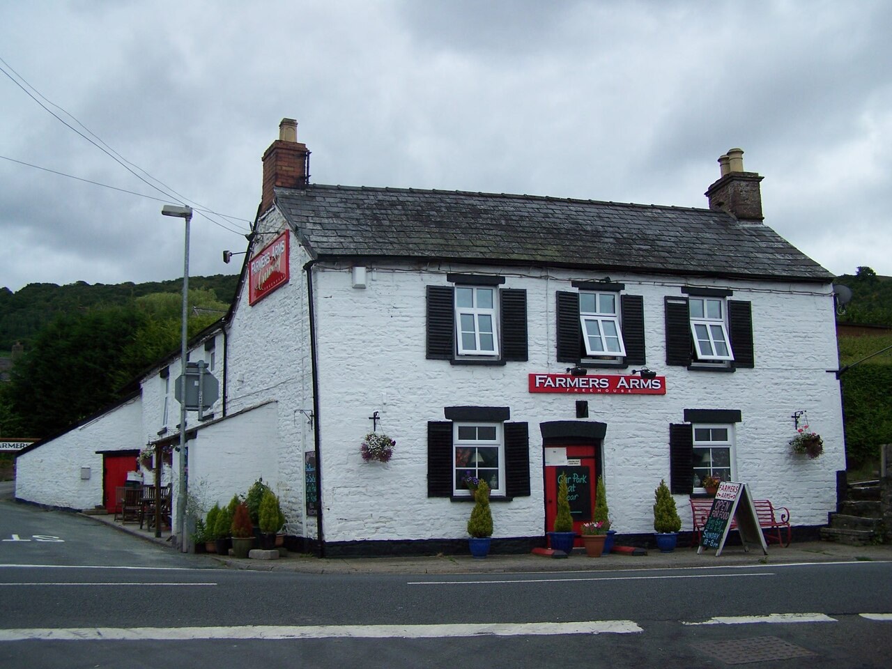
Photo: Geoff Pick · CC BY-SA 2.0 · cropped
The Fox verdict
A small valley village with an unusually layered story
Cwmdu brings together a community-owned pub, a historic church and a substantial ridge walk.
The Farmers Arms supplies the village's food, cask ale and gathering place; St Michael's preserves a fifteenth-century tower, reused rood-screen pieces and the stone brought from a nearby field by the church's antiquarian vicar. The 8.5-mile Cefn Moel circuit opens out towards Llangorse Lake, Pen y Fan, the Black Mountains and Crickhowell.
Where to go
Places in Cwmdu
Every place below is checked against a published source, listed with what it is and how long to give it.
Local signatures
3 placesCashells
A three-generation butcher and deli stocking more than seventy-five cheeses and meat from Black Mountains farms.
- Visit length
- Editorial estimate: allow around 30 minutes.
- Locality
- Crickhowell
Book-ish
An independent bookshop combined with a café in Crickhowell's independent high street.
- Visit length
- Editorial estimate: allow around 45 minutes.
- Locality
- Crickhowell
Llangorse Multi Activity Centre
Family options include indoor climbing, horse riding, a junior challenge course and archery.
- Visit length
- Editorial estimate: allow around 2 hours.
- Locality
- Llangorse
- Access
- Minimum ages apply to the activities.
Food & drink
1 place
The Farmers Arms
A community-owned pub with a hop-decorated bar, a large fireplace and a cast-iron range, serving home-cooked food, a carvery and two changing cask ales.
- Visit length
- Editorial estimate: allow around 75 minutes for a meal or drink.
- Locality
- Cwmdu, on the A479
- Access
- Dogs are welcome, and there is a beer garden.
Walks & outdoors
1 placeCwmdu, Cefn Moel & Bwlch Circular
The circuit joins the Beacons Way, climbs to Cefn Moel and its cairns, reaches Bwlch and returns through fields via Felindre, with broad ridge views.
- Visit length
- Editorial estimate: allow around 3½ hours.
- Locality
- From Cwmdu Village Hall
- Access
- The route is graded moderate.
History & heritage
2 placesChurch of St Michael
Largely rebuilt in 1831–33, the church retains an especially fine fifteenth-century tower, a medieval font pedestal and an early medieval inscribed stone in a south buttress.
- Visit length
- Editorial estimate: allow around 30 minutes.
- Locality
- On a spur above the lower modern settlement
Tretower Court and Castle
A Cadw site pairing a massive Norman-era circular tower with a restored medieval court, including a great hall evoking a 1460s feast.
- Visit length
- Editorial estimate: allow around 90 minutes.
- Locality
- Nearby on the A479
- Access
- Dogs on short leads are welcome at ground-floor level.
No places match this filter. Choose All places to reset the list.
Three ways to explore Cwmdu
Signature outings
A pub the village owns
Choose home-cooked food or a carvery at the community-owned Farmers Arms, with two changing cask ales on the bar.
Cefn Moel on foot
Follow the 8.5-mile moderate circular from Cwmdu Village Hall onto the Beacons Way and over Cefn Moel.
Tretower's medieval pairing
See a massive Norman-era circular tower beside a restored medieval court whose great hall evokes a 1460s feast.
The village story
Cwmdu Village Guide
A dark-valley village of community spirit, church history, ridge walking and deep archaeology.
The community pub and dark valley
The Farmers Arms stands on the A479 with hops strung along the bar, a cast-iron range in the grate and a large open fireplace. It is community-owned, and a good deal rests on it. The kitchen leans on home-cooked food and a carvery. You will find beer-battered fish of the day, slow-cooked belly pork with mustard mash and apple gravy, a vegetable curry, the Farmers Arms burger and a vegan "Bad Boy" burger; on Sundays there is roast beef, lamb and pork, a homemade nut roast, seasonal fruit pie and a caramel Belgian waffle. Two cask ales change on the bar, usually one national and one local. Dogs are welcome and there is a beer garden.
Cwmdu means "dark valley". The village runs along the road as it drops through the Rhiangoll valley, about six kilometres north-west of Crickhowell, with the older houses climbing to a spur where the church sits above the newer settlement below.
St Michael's and Carnhuanawc
St Michael's was largely rebuilt in 1831-33 but kept its fifteenth-century tower, which Cadw calls especially fine. The font is an early-twentieth-century bowl set on a thirteenth-century clustered-shaft pedestal. The reredos and communion rails are older pieces of the church's rood screen, reused by a former vicar.
That vicar was Thomas Price, and one thing he did in the village is easy to walk up to. Built into a south buttress is an early medieval inscribed stone reading CATACUS HIC IACIT FILIUS TEGERNACUS — "Here lies Cattoc son of Teyrnoc." Price carried it here from a field a mile off and set it into the wall. He arrived as vicar in 1825, wrote under the bardic name Carnhuanawc, produced a major history of Wales, campaigned for the Welsh language and helped support a school for blind harpists. He died in 1848 and is buried here.
Ridge walking and older ground
For walking, the village hall is the usual starting point for an 8.5-mile circular over Cefn Moel. It joins the Beacons Way, climbs past the summit cairns, drops down to Bwlch and returns through fields by way of Felindre. From the ridge you can pick out Llangorse Lake, Pen y Fan, the Black Mountains and Crickhowell laid out below.
The antiquary Theophilus Jones called this arable vale the "granary of Brecknockshire". Above it sits Pen-y-Gaer, a Roman auxiliary fort roughly midway between the garrisons at Brecon and Abergavenny. In the drought summer of 2018 aerial photographs showed its buried internal plan. Nearby, a small Old Red Sandstone figure, thought to be a late Iron Age or Romano-British deity, is built into Middle Gaer House and can be seen from the road.
Connections and show day
The A479 carries you south to Crickhowell and north to Talgarth. Abergavenny, about eleven miles off, is the nearest railway station. The X12 bus calls at the Farmers Arms on Tuesdays only, one morning run towards Crickhowell and Abergavenny and an afternoon return. For anything more than the pub you will want the car: Tretower Court and Castle is nearby on the A479, and Crickhowell has Cashells, a three-generation butcher and deli stocking more than seventy-five cheeses, and Book-ish, a bookshop with a café.
Once a year the fields fill up. The Cwmdu and District Show has run since 1988, with sheep classes, pony qualifiers, vintage machinery, country crafts, cookery and a dog show, and children's competitions.
Stay around Brecon Beacons
Make a longer stay of it
Travel Fox holiday homes around Brecon Beacons, linked directly to their property pages.
For homeowners
Own a holiday home near Cwmdu?
We manage holiday lets across the UK from 12% commission, charged after cleaning costs, with no lock-in. A co-founder visits before you decide.
How our holiday let management works →
A guide with a point of view
Written from research. Edited for real journeys.
Use the Official site links for live practical details, then use this guide for context, ideas and room to explore.
Photography credits & licences
Third-party photographs are credited to their named creators and reused under the linked Creative Commons licence or public-domain dedication. Travel Fox stores an optimised local copy; the file-specific changes and any browser-applied display crop are disclosed below. Reused photographs link both to the Wikimedia Commons source record and to the declared source image; Travel Fox's own photographs carry no such record and are marked as ours. These image licences do not cover Travel Fox text, branding or page design.
- File:Farmers Arms, Cwmdu - geograph.org.uk - 2025987.jpg — photograph by Geoff Pick; Farmers Arms, Cwmdu by Geoff Pick. Source record on Wikimedia Commons. Declared source image. Licence: CC BY-SA 2.0. File changes: Downloaded from Wikimedia Commons, resized to a maximum 1920px edge and encoded as an optimised JPEG. Display changes: Displayed with responsive CSS cropping.
Sources
Every place on this page is checked against a published source. Each entry links the record we used and names who publishes it.
- The Farmers Arms — the-farmers-arms.com operator, sector body or destination organisation
- Church of St Michael — heritage.churchinwales.org.uk other published source
- Cwmdu, Cefn Moel & Bwlch Circular — beacons-npa.gov.uk statutory register or public authority
- Tretower Court and Castle — cadw.gov.wales statutory register or public authority
- Cashells — visitcrickhowell.wales operator, sector body or destination organisation
- Book-ish — book-ish.co.uk operator, sector body or destination organisation record not machine-readable; publisher restricts automated access
- Llangorse Multi Activity Centre — llangorse.com operator, sector body or destination organisation