
Waterfall Country
Ystradfellte
A remote settlement on a low spur in the Afon Mellte valley, with wooded gorges, caves and waterfalls farther south.
- Best for
- The Four Falls Trail and Porth yr Ogof
- Give it
- Three to four hours for the five-mile Four Falls Trail
- Don't miss
- The path behind the curtain of water at Sgwd yr Eira
Photo: Gordon Hatton · CC BY-SA 2.0 · cropped
The Fox verdict
A quiet base for water working through rock
Ystradfellte is a sparse valley settlement whose strongest reasons to visit are the wooded gorges, caves and waterfalls around it.
The strenuous Four Falls Trail is the main draw, while Porth yr Ogof shows the Afon Mellte entering limestone before resurfacing at Blue Pool. In the village, the reopened New Inn and the late-medieval character of Saint Mary's Church add useful stops before or after the landscape outings.
Where to go
Places in Ystradfellte
Every place below is checked against a published source, listed with what it is and how long to give it.
Local signatures
3 placesNew Inn
A small 16th-century village pub in Waterfall Country, reopened in April 2026 after a two-year closure.
- Visit length
- Editorial estimate: around 75 minutes
- Locality
- at the centre of the village
- Access
- Telephone: 029 2297 0755.
Dan yr Ogof / National Showcaves
A family attraction with three visitor caves, more than 200 life-size dinosaur models, a Shire horse centre, a farm area and two covered play areas.
- Visit length
- Editorial estimate: around 2 hours
- Locality
- in the wider area
Craig-y-nos Country Park
Publicly accessible 40-acre grounds of a Victorian castle, with remnants of walled kitchen gardens, rock gardens, a croquet lawn, rose garden and exotic specimen trees.
- Visit length
- Editorial estimate: around 90 minutes
- Locality
- west of the village
Food & drink
2 placesRhos Filling Station & Shop
A small filling-station shop carrying basic provisions, ice cream, confectionery and soft drinks.
- Visit length
- Editorial estimate: around 15 minutes
- Locality
- near the Clun-Gwyn waterfall parking, outside the village centre
- Access
- The filling station sells diesel only, not petrol.
Penderyn Distillery
The original Penderyn whisky distillery offers an hour-long tour of the mill, mash tun and distinctive stills, ending with tastings.
- Visit length
- Editorial estimate: Around 1 hour
- Locality
- south-east of the village near the A4059
- Access
- Advance booking is advisable. Under-14s cannot enter the production area.
Walks & outdoors
2 placesFour Falls Trail
A strenuous five-mile circuit to Sgwd Clun-Gwyn, Sgwd Isaf Clun-Gwyn, Sgwd y Pannwr and Sgwd yr Eira.
- Visit length
- Editorial estimate: Around 3-4 hours
- Locality
- through woodland gorges on the Afon Mellte and Afon Hepste
- Access
- Optional link paths are narrow, rocky, stepped and slippery. The trail is unsuitable for buggies, pushchairs and wheelchairs, and there are no toilets at the falls.
Porth yr Ogof
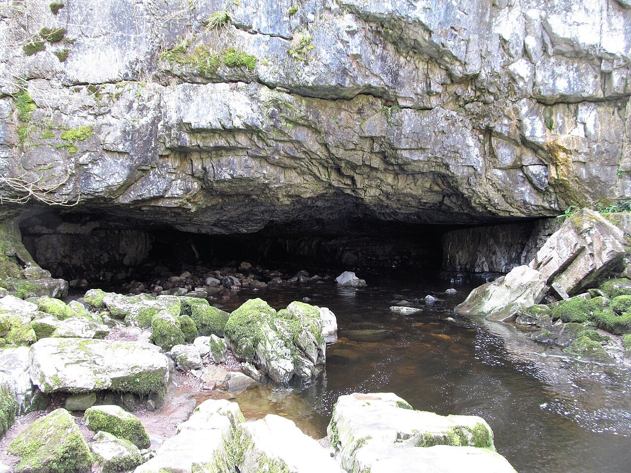
The Afon Mellte enters Carboniferous Limestone at Wales's largest cave mouth and resurges roughly 300 metres south at Blue Pool.
- Visit length
- Editorial estimate: around 30 minutes
- Locality
- a short walk from Cwm Porth car park
- Access
- Steps to the entrance are steep, rocky and potentially slippery. Further cave passages are for experienced cavers and have seen fatalities.
History & heritage
2 placesChurch of Saint Mary
A probably early 15th-century church with a later west tower, a fine late-medieval chancel roof, an octagonal font and a memorial carved with a winged skull and bones.
- Visit length
- Editorial estimate: around 45 minutes
- Locality
- above the houses
Maen Llia
A massive Bronze Age conglomerate standing stone measuring 3.61 metres high and 2.75 metres wide.
- Visit length
- Editorial estimate: around 30 minutes
- Locality
- north of the village
No places match this filter. Choose All places to reset the list.
Three ways to explore Ystradfellte
Signature outings
Four falls in one strenuous circuit
Allow three to four hours for the five-mile waymarked trail through woodland gorges to four falls, including Sgwd yr Eira and its path behind the water.
The broad mouth of Porth yr Ogof
See the Afon Mellte enter the limestone at Wales's largest cave mouth, then follow the short surface walk towards its resurgence at Blue Pool without entering the cave passages.
Saint Mary's tower and chancel roof
Look for the battered tapering west tower, the late-medieval 10-by-6-panel chancel roof and the memorial carved with a winged skull and bones.
The village story
Ystradfellte Village Guide
A sparse settlement in the Afon Mellte valley, shaped by the waterfalls, wooded gorges and limestone caves around it.
Village food and provisions
Ystradfellte is a scatter of houses on a low spur in the Afon Mellte valley, south-west of Brecon. At the centre of the village, the small 16th-century New Inn reopened in April 2026 after two years shut.
For provisions, head beyond the village to Rhos Filling Station and Shop near the Clun-Gwyn waterfall parking. It carries basic groceries, ice cream, confectionery and soft drinks, and sells diesel but not petrol. The valley's walks, caves and falls shape a visit more than village services do.
Waterfalls and limestone
Water works through rock around Ystradfellte. Above the village the Afon Llia and Afon Dringarth join to make the Mellte, while farther south the Mellte, Hepste and Nedd Fechan have cut wooded gorges and falls. The strenuous Four Falls Trail takes three to four hours over five miles, passing Sgwd Clun-Gwyn, Sgwd Isaf Clun-Gwyn and Sgwd y Pannwr on the Mellte before Sgwd yr Eira on the Hepste. A track formerly used by sheep farmers passes behind the water at Sgwd yr Eira. Expect spray and slippery footing; the waterfall link paths are narrow, rocky and stepped. The trail is unsuitable for buggies and wheelchairs, and there are no toilets at the falls.
Nearer the houses, the Afon Mellte vanishes into limestone at Porth yr Ogof, Wales's largest cave mouth, about twenty metres wide and three metres high. The river resurfaces roughly three hundred metres south at Blue Pool; both are a short walk from Cwm Porth car park. The cave passages beyond the entrance are for experienced cavers and have seen fatalities. In 1835 William Weston Young wrote of the cave that "there is not another in the valley of so large dimensions".
Getting to Ystradfellte
Aberdare is the nearest railway station, about ten miles away by road, and there is no direct bus into Ystradfellte. Minor roads reach the village from the A4059 above Penderyn or from Pontneddfechan. They are single-track in places, and car parks near the falls can fill before midday.
Saint Mary's Church
The Church of Saint Mary stands above the houses: the body is probably early fifteenth-century, the battered tapering west tower with its battlemented parapet later, fifteenth to sixteenth-century, and the whole was restored in 1882. Inside are a ten-by-six-panel late-medieval chancel roof, a whitewashed octagonal font, and a painted memorial to Thomas Jones of Berthlwyd, who died in 1779, carved with a winged skull and bones.
A deliberately thin history
The history is thin on purpose. An 1813 survey drawing shows only four or five houses by the church, and this may never have been a proper medieval village at all. In 1316 the Welsh rebel Llywelyn Bren surrendered to the marcher lords here before being taken to Cardiff and executed. And as recently as December 2005, sixteen people in four farmhouses in the Nedd valley became the last community in England and Wales to reach the mains, after nearly three miles of line was strung across the hills. "It will be much more convenient than it is now," said Jannet Llewellyn of Berthlwyd farm, which is what you say when you have managed a long time without.
Stay around Brecon Beacons
Make a longer stay of it
Travel Fox holiday homes around Brecon Beacons, linked directly to their property pages.
For homeowners
Own a holiday home near Ystradfellte?
We manage holiday lets across the UK from 12% commission, charged after cleaning costs, with no lock-in. A co-founder visits before you decide.
How our holiday let management works →
A guide with a point of view
Written from research. Edited for real journeys.
Use the Official site links for live practical details, then use this guide for context, ideas and room to explore.
Photography credits & licences
Third-party photographs are credited to their named creators and reused under the linked Creative Commons licence or public-domain dedication. Travel Fox stores an optimised local copy; the file-specific changes and any browser-applied display crop are disclosed below. Reused photographs link both to the Wikimedia Commons source record and to the declared source image; Travel Fox's own photographs carry no such record and are marked as ours. These image licences do not cover Travel Fox text, branding or page design.
- File:Porth yr Ogof cave entrance - geograph.org.uk - 5342679.jpg — photograph by Gordon Hatton; Porth yr Ogof cave entrance by Gordon Hatton. Source record on Wikimedia Commons. Declared source image. Licence: CC BY-SA 2.0. File changes: Downloaded from Wikimedia Commons, resized to a maximum 1920px edge and encoded as an optimised JPEG. Display changes: Displayed with responsive CSS cropping.
Sources
Every place on this page is checked against a published source. Each entry links the record we used and names who publishes it.
- New Inn — camra.org.uk operator, sector body or destination organisation
- Rhos Filling Station & Shop — ystradfellte.wixsite.com other published source
- Church of Saint Mary — cadwpublic-api.azurewebsites.net other published source
- Four Falls Trail — naturalresourceswales.gov.uk statutory register or public authority
- Porth yr Ogof — fforestfawrgeopark.org.uk other published source
- Dan yr Ogof / National Showcaves — visitwales.com operator, sector body or destination organisation
- Penderyn Distillery — penderyn.wales operator, sector body or destination organisation
- Craig-y-nos Country Park — beacons-npa.gov.uk statutory register or public authority
- Maen Llia — coflein.gov.uk statutory register or public authority