
Harbour, dunes and deep history
Portballintrae
A sheltered horseshoe bay where fishing boats, coastal paths, the Lissanduff earthworks and a remarkable Armada story meet.
- Best for
- Coastal walking, harbour views and layered history
- Give it
- A half day, or longer for the Causeway walk
- Don't miss
- The off-road route around Runkerry Head
Photo: Kenneth Allen · CC BY-SA 2.0 · cropped
The Fox verdict
A compact harbour base with a coast-sized story
Portballintrae combines a sheltered bay and small family beach with food, the Lissanduff earthworks and an off-road coastal route around Runkerry Head.
The harbour still receives fishing boats alongside pleasure craft, while Salmon Rock, the Porthole and Bushfoot Clubhouse provide distinct reasons to linger. Beyond the bay, Lissanduff and the Girona story add unusually deep historical texture.
Where to go
Places in Portballintrae
Every place below is checked against a published source, listed with what it is and how long to give it.
Local signatures
3 placesPorthole Bar & Restaurant
A harbour-facing bar and restaurant with an open peat fire, known for fresh bay chowder and Guinness-braised beef and serving four gins made in Portballintrae.
- Visit length
- Editorial estimate: allow around 75 minutes
- Locality
- at the Bayview Hotel
Portballintrae to Giant's Causeway Walk
An off-road route crossing the Threequarter Footbridge, following boardwalk and dunes beside the heritage railway, passing Runkerry House and climbing the clifftops around Runkerry Head.
- Visit length
- Editorial estimate: allow around 180 minutes
- Locality
- from the seafront car park along the Runkerry Head coast
- Access
- Surfaces can be muddy or slippery, and there are unprotected cliff edges.
Lissanduff Earthworks
Two large banked earthworks, one centred on a natural spring; their date and purpose remain unresolved.
- Visit length
- Editorial estimate: allow around 45 minutes
- Locality
- above the village
- Access
- Free to enter, though access can occasionally be restricted for works.
Food & drink
2 placesBushfoot Clubhouse Bar & Restaurant
A relaxed clubhouse serving a Sunday carvery, curry nights, an Ulster fry and homemade pizzas available to take away.
- Visit length
- Editorial estimate: allow around 75 minutes
- Locality
- at Bushfoot Golf Club
- Access
- Visitors calling in for food are welcome.
Artisan Food & Craft Market
A market of Northern Irish makers and producers offering jams and chutneys, baked goods, plants, art, jewellery, skincare, textiles and woodcraft.
- Visit length
- Editorial estimate: allow around 60 minutes
- Locality
- in Portballintrae Village Hall
- Access
- The source records it as a regular 2026 market; entry and parking are advertised as free.
History & heritage
2 placesOld Bushmills Distillery
A working distillery whose official site says it has operated since 1608.
- Visit length
- Editorial estimate: allow around 90 minutes
- Locality
- in Bushmills
- Access
- Working-distillery tours are available, though production can pause for maintenance and children under eight cannot join the tour.
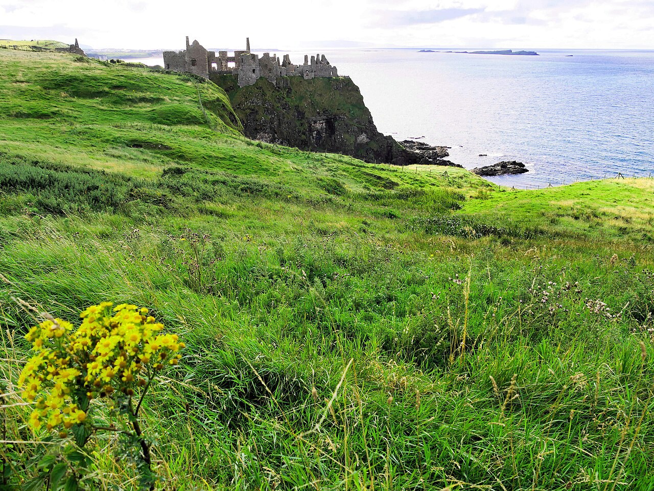
Dunluce Castle
A cliff-top castle built by the MacQuillans around 1500, with excavated cobbled streets and merchants' houses from its associated town.
- Visit length
- Editorial estimate: allow around 75 minutes
- Locality
- on its cliff
Things to do
1 place
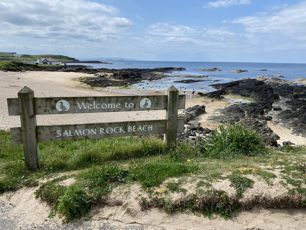
Salmon Rock Beach
A small enclosed sandy beach, with rocks at either end and offshore, popular with families and small children and served by picnic areas, free parking, toilets and disabled facilities.
- Visit length
- Editorial estimate: allow around 45 minutes
- Locality
- in the centre of the village
- Access
- Swimming is generally discouraged because conditions are challenging; there is no lifeguard service. Dog restrictions apply from 1 June to 15 September.
No places match this filter. Choose All places to reset the list.
Three ways to explore Portballintrae
Signature outings
Salmon Rock
Settle beside a small enclosed sandy beach with rocks at either end, picnic areas and facilities used by families and small children.
Dunluce Castle
Explore a cliff-top castle where excavated cobbled streets and merchants' houses reveal the associated town.
Market day
Browse jams, baked goods, plants, art, jewellery, skincare, textiles and woodcraft from Northern Irish makers and producers.
The village story
Portballintrae Village Guide
Harbour food, a family beach, coastal paths and centuries of history around a sheltered horseshoe bay.
Harbour, Bay and Salmon Rock
The Porthole Bar keeps an open peat fire going, and it faces the harbour with the Atlantic just beyond it. The two dishes it is known for are fresh bay chowder and Guinness-braised beef, and the drinks list leans local: four gins are made in Portballintrae itself, one of them carrying the name of the cook Paula McIntyre. It is the bar of the Bayview Hotel, and it serves as a popular meeting place.
The village sits at the mouth of the River Bush, wrapped around a sheltered horseshoe bay. A few fishing boats still work out of the harbour, though pleasure craft have increasingly replaced working boats. Across the water are Runkerry Headland and Runkerry House, and behind Bushfoot Strand lies an old dune system.
Salmon Rock is the beach in the centre of the village, small and enclosed, with rocks at either end and more offshore. It comes with picnic areas, free parking, toilets and disabled facilities, and it draws families and small children. Swimming is discouraged, the conditions being difficult and the beach unguarded, so anyone set on a proper swim goes to Whiterocks, about three and a half miles west. Dogs are restricted between 1 June and 15 September.
Clubhouse, Makers and the Causeway Walk
Up at the golf club, the Bushfoot Clubhouse runs a Sunday carvery, curry nights, an Ulster fry and homemade pizzas you can take away, and visitors calling in for food are welcome. Bushfoot Golf Club has been going since 1890; its nine holes are played from different tees to make an eighteen-hole, par-70 round. The Portballintrae Boat Club serves drinks and shows sport, but you sign in with a member, so it is not a walk-in.
For provisions there is Today's Local on Beach Road, beside the beach facilities. The village hall hosts a regular artisan food and craft market, with jams and chutneys, baked goods, plants, jewellery, skincare and woodcraft from Northern Irish makers; entry and parking are free.
The walk most people take goes from the seafront car park to the Giant's Causeway, about four miles there and back. It crosses the River Bush on the footbridge known locally as the Threequarter, then follows boardwalk and dune beside the old heritage railway, passes Runkerry House, and climbs onto the clifftops around Runkerry Head. The surfaces get muddy and the cliff edges are unprotected, but the whole section is off-road, and the Causeway itself is only about a mile and a third off.
Armada Finds and Lissanduff Earthworks
In 1588 the Spanish Armada warship Girona went down off this coast. In May 1967 the first of some twelve thousand recovered objects was landed at Portballintrae harbour: gold and silver coins, jewellery, silver plate, a bronze cannon. Robert Sténuit's team had located the wreck that year, and much of the collection now sits in the Ulster Museum.
Above the village are the Lissanduff earthworks, two large banked enclosures, one built around a natural spring. Their date and purpose have never been settled. The official assessment is only that they are, in the words of the Department for Communities, "certainly not 'ordinary' raths." They are free to walk into, though access is occasionally restricted for works.
The Tramway and Seaside Heritage
The tramway that once ran along this shore opened in 1883 as the first in the world powered by hydroelectricity. It carried Belfast Blitz evacuees and wartime workers before closing in 1949, and a tourist railway now traces part of the route from Bushmills.
Seaport Lodge, Georgian and dating from around 1770, was built as a bathing lodge and summer residence for the Leslie family; in 1832 the village amounted to a handful of houses lived in mainly by pilots. The Old Coastguard Cottages, a terrace of three with a square watchtower, went up in the 1870s.
Connections Beyond the Harbour
Old Bushmills Distillery, working since 1608, is a mile and a half away, and Dunluce Castle stands on its cliff about a mile and two-thirds in the other direction. The nearest ordinary railway station is at Portrush, a little over four miles off; the B145 links the village to the coast road, and buses stop at the Bayview Hotel.
The working boats share the harbour with the pleasure craft, and children play on Salmon Rock below the village.
Stay around Causeway Coast
Make a longer stay of it
Travel Fox holiday homes around Causeway Coast, linked directly to their property pages.
For homeowners
Own a holiday home near Portballintrae?
We manage holiday lets across the UK from 12% commission, charged after cleaning costs, with no lock-in. A co-founder visits before you decide.
How our holiday let management works →
A guide with a point of view
Written from research. Edited for real journeys.
Use the Official site links for live practical details, then use this guide for context, ideas and room to explore.
Photography credits & licences
Third-party photographs are credited to their named creators and reused under the linked Creative Commons licence or public-domain dedication. Travel Fox stores an optimised local copy; the file-specific changes and any browser-applied display crop are disclosed below. Reused photographs link both to the Wikimedia Commons source record and to the declared source image; Travel Fox's own photographs carry no such record and are marked as ours. These image licences do not cover Travel Fox text, branding or page design.
- File:Salmon Rock Beach - geograph.org.uk - 8071092.jpg — photograph by Kenneth Allen; Salmon Rock Beach by Kenneth Allen. Source record on Wikimedia Commons. Declared source image. Licence: CC BY-SA 2.0. File changes: Downloaded from Wikimedia Commons, resized to a maximum 1920px edge and encoded as an optimised JPEG. Display changes: Displayed with responsive CSS cropping.
- File:Irlanda del Nord -.Dunluce Castle.jpg — photograph by Mario Falcetti; Own work. Source record on Wikimedia Commons. Declared source image. Licence: CC BY 4.0. File changes: Downloaded from Wikimedia Commons, resized to a maximum 1920px edge and encoded as an optimised JPEG. Display changes: Displayed with responsive CSS cropping.
Sources
Every place on this page is checked against a published source. Each entry links the record we used and names who publishes it.
- Porthole Bar & Restaurant — visitcausewaycoastandglens.com operator, sector body or destination organisation
- Bushfoot Clubhouse Bar & Restaurant — bushfootgolfclub.co.uk operator, sector body or destination organisation
- Salmon Rock Beach — causewaycoastandglens.gov.uk statutory register or public authority
- Portballintrae to Giant's Causeway Walk — visitcausewaycoastandglens.com operator, sector body or destination organisation
- Lissanduff Earthworks — communities-ni.gov.uk statutory register or public authority
- Artisan Food & Craft Market — visitcausewaycoastandglens.com operator, sector body or destination organisation
- Old Bushmills Distillery — bushmills.eu operator, sector body or destination organisation
- Dunluce Castle — communities-ni.gov.uk statutory register or public authority