
At the foot of Great Langdale
Elterwater
A compact village at the foot of Great Langdale, where a historic inn, a small lake and low-level walks anchor the visit.
- Best for
- Low-level walks, tarns and valley views
- Give it
- A relaxed half day on foot
- Don't miss
- Skelwith Force on the River Brathay
Photo: Mark Anderson · CC BY-SA 2.0 · cropped
The Fox verdict
A small village with a big walking horizon
Elterwater pairs a historic inn and one of the district's smallest lakes with routes into Great and Little Langdale.
Come for the relatively flat river walk to Skelwith Force, a tarn outing or a route to Cathedral Cavern. The Langdale Pikes frame the day, while the Britannia Inn gives it a natural village base.
Where to go
Places in Elterwater
Every place below is checked against a published source, listed with what it is and how long to give it.
Local signatures
3 placesElterwater Lake
One of the Lake District's smallest lakes, fed by Great Langdale Beck and named from the Old Norse for swan lake.
- Visit length
- Editorial estimate: Allow around 30 minutes
- Locality
- at the foot of Elterwater village
Elterwater to Skelwith Bridge Walk
A riverside walk from Elterwater past the lake and Skelwith Force to Skelwith Bridge; return by the same route.
- Visit length
- Editorial estimate: Allow around 2 hours
- Locality
- between Elterwater and Skelwith Bridge
Great Langdale Valley
The valley opens beyond Elterwater towards Stickle Ghyll, Harrison Stickle and the Langdale Pikes.
- Visit length
- Editorial estimate: Allow around 90 minutes
- Locality
- beyond Elterwater in Great Langdale
Food & drink
1 place
The Britannia Inn
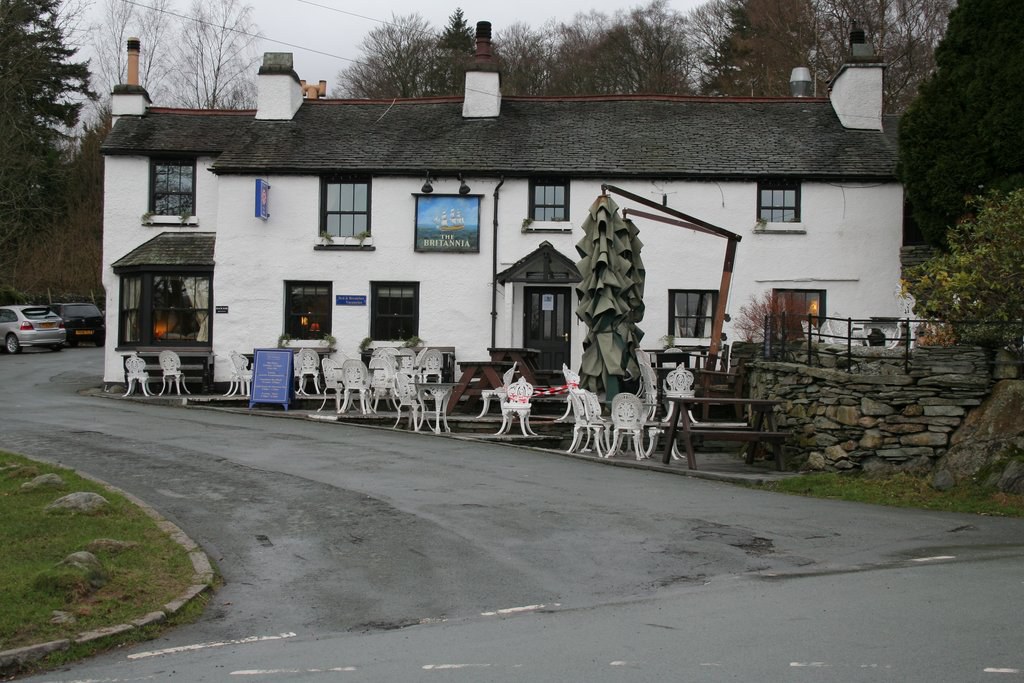
A traditional 500-year-old inn with exposed stone and beams, a village-green setting and food drawing on local producers.
- Visit length
- Editorial estimate: Allow around 75 minutes
- Locality
- on Elterwater village green
Walks & outdoors
1 placeLoughrigg Tarn
A walk to a small, peaceful tarn where still water can reflect the Langdale Pikes.
- Visit length
- Editorial estimate: Allow around 60 minutes
- Locality
- near Elterwater
History & heritage
1 placeCathedral Cavern
A disused quarry cave near Little Langdale that is incorporated into many local walks.
- Visit length
- Editorial estimate: Allow around 2 hours
- Locality
- near Little Langdale
No places match this filter. Choose All places to reset the list.
Three ways to explore Elterwater
Signature outings
The Village Inn
Pause at the 500-year-old Britannia Inn for its exposed stone, low beams and village-green outlook.
Loughrigg Tarn
Walk to Loughrigg Tarn and look for the Langdale Pikes reflected in still water.
Cathedral Cavern
Fold the disused quarry cave near Little Langdale into a local walking route.
The village story
Elterwater: Inn, Water and Working Valley
A compact account of the inn, lake, high fells, industrial past and the journey into Great Langdale.
Village Green and Swan Lake
The Britannia Inn stands on the village green, and it has been there for five hundred years. It is one of the most photographed pubs in the Lake District, which is the sort of claim that usually means very little, except that here you can see why: exposed stone, low beams, a green out front, and the whole of Great Langdale rising behind it. The kitchen leans on local producers. You can order home-made Cumberland pâté with port sauce, Somerset Brie in a crisp thyme crumb, Plumgarths of Kendal Cumberland sausage, or slowly braised South Lakes lamb Henry. Lunch, soup and sandwiches run from 2 to 4pm; dinner from 5:30 to 8:30. There is a Britannia Brûlée and a home-made sticky toffee pudding, the latter being more or less compulsory in this part of Cumbria.
The village sits at the foot of the valley where Great Langdale Beck runs down into Elterwater lake, one of the smallest lakes in the district. The name is Old Norse — elptr vatn, swan lake — and the birds still turn up.
Pikes, Falls and Tarns
To the northwest the Langdale Pikes rise sharply. Harrison Stickle is 736 metres, Pike o' Stickle 709, and from the green they look considerably higher than that.
The walking is the reason most people come. An out-and-back route follows the River Brathay down to Skelwith Bridge past Skelwith Force, a waterfall dramatic enough for its size, on ground that stays relatively flat. Another walk reaches Loughrigg Tarn, a small tarn that reflects the Pikes when the water is still. Cathedral Cavern, a disused quarry cave over toward Little Langdale, gets folded into a good many local routes. Beyond the village the valley opens toward Stickle Ghyll and the higher fells.
Gunpowder and Green Slate
Langdale Co-operative is a village shop in nearby Chapel Stile. The former gunpowder works has a longer story. In 1824 a Kendal banker named David Huddlestone built it here, on the site of earlier corn and fulling mills, water-powered from the beck. Within a few years it was exporting to North America and South Africa and supplying the local quarries and mines. In 1840 an explosion at the works killed several men. It closed around 1928, and the buildings later became holiday accommodation.
The other local industry was slate. Elterwater Quarry worked the green Lakeland slate that turns up in walls and roofs across the region — compressed volcanic ash, some 450 million years old, which is a long time for a building material to wait around.
Chapel and the Road In
Holy Trinity Church is in nearby Chapel Stile, about 0.7 miles from Elterwater in a straight line.
Getting here takes some doing. There is no railway — Windermere is the nearest — so you drive in on the A593 to Skelwith Bridge and then the B5343 into the valley. In season the 516 Langdale Rambler bus runs up from Ambleside.
Swans on the Lake
The swans, meanwhile, keep to the lake, as they have since someone first thought to name it after them.
Stay around Lake District
Make a longer stay of it
Travel Fox holiday homes around Lake District, linked directly to their property pages.
For homeowners
Own a holiday home near Elterwater?
We manage holiday lets across the Lake District from 12% commission, charged after cleaning costs, with no lock-in. A co-founder visits before you decide.
Holiday let management in the Lake District →
A guide with a point of view
Written from research. Edited for real journeys.
Use the Official site links for live practical details, then use this guide for context, ideas and room to explore.
Photography credits & licences
Third-party photographs are credited to their named creators and reused under the linked Creative Commons licence or public-domain dedication. Travel Fox stores an optimised local copy; the file-specific changes and any browser-applied display crop are disclosed below. Reused photographs link both to the Wikimedia Commons source record and to the declared source image; Travel Fox's own photographs carry no such record and are marked as ours. These image licences do not cover Travel Fox text, branding or page design.
- File:Britannia Inn, Elterwater - geograph.org.uk - 691149.jpg — photograph by Mark Anderson; Mark Anderson. Source record on Wikimedia Commons. Declared source image. Licence: CC BY-SA 2.0. File changes: Downloaded from Wikimedia Commons, resized to a maximum 1920px edge and encoded as an optimised JPEG. Display changes: Displayed with responsive CSS cropping.
Sources
Every place on this page is checked against a published source. Each entry links the record we used and names who publishes it.
- The Britannia Inn — thebritanniainn.com operator, sector body or destination organisation
- Elterwater Lake — lakedistrict.gov.uk statutory register or public authority
- Elterwater to Skelwith Bridge Walk — lakedistrict.gov.uk statutory register or public authority
- Loughrigg Tarn — lakedistrict.gov.uk statutory register or public authority
- Cathedral Cavern — cnp.org.uk other published source
- Great Langdale Valley — lakedistrict.gov.uk statutory register or public authority