
Iron, ideas and open ground
Tredegar
A planned industrial town where a cast-iron clock, the roots of the NHS and reclaimed upland parkland tell one connected story.
- Best for
- Industrial history, NHS heritage and contrasting parkland
- Give it
- A full day across the town and its northern edge
- Don't miss
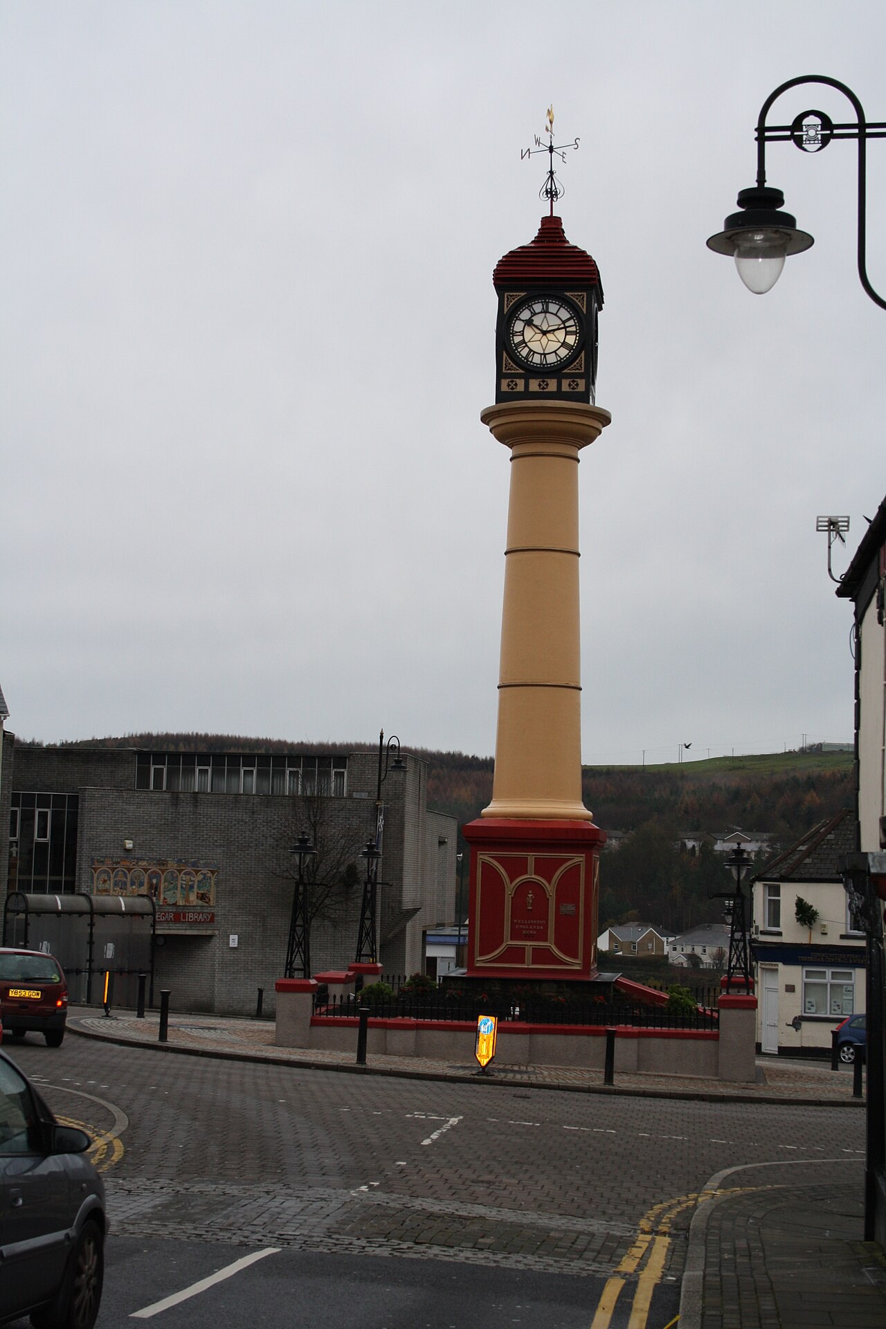
- The Town Clock on The Circle
Photo: michael p brunt · CC BY-SA 2.0 · cropped
The Fox verdict
A town that turned industry into inheritance
Tredegar pairs the physical legacy of iron and coal with the social history that helped shape the National Health Service.
Begin at the cast-iron Town Clock and the local museum on The Circle, then connect the Victorian grounds of Bedwellty House with the Tredegar Medical Aid Society story. Parc Bryn Bach and the Aneurin Bevan Memorial Stones open that history out into reclaimed land and high moorland.
Where to go
Places in Tredegar
Every place below is checked against a published source, listed with what it is and how long to give it.
Local signatures
3 placesTredegar Local History Museum
A free local-history museum inside Tredegar Library on The Circle, overlooked by the Town Clock.
- Visit length
- Editorial estimate: Allow around 45 minutes
- Locality
- at Tredegar Library on The Circle
- Access
- Opening is limited to selected periods on Wednesdays, Fridays and Saturdays; check current details before travelling.
Aneurin Bevan Memorial Stones
One large stone represents Aneurin Bevan and three smaller stones represent Ebbw Vale, Rhymney and Tredegar, the towns of his constituency.
- Visit length
- Editorial estimate: Allow around 75 minutes
- Locality
- at the northern entrance to the Sirhowy Valley Walk outside Tredegar
- Access
- This is an exposed upland walking stop; choose conditions and footwear accordingly.
Tredegar Medical Aid Society Heritage Centre
A heritage centre commemorating the subscription-based Tredegar Medical Aid Society, whose approach informed Aneurin Bevan's model for the National Health Service.
- Visit length
- Editorial estimate: Allow around 45 minutes
- Locality
- in Tredegar
- Access
- Confirm current public access before making a special journey.
Walks & outdoors
1 placeParc Bryn Bach
A 340-acre country park around a 26-acre lake, with a circular lakeside walk, nature trail, mountain-bike trail, visitor centre and play park.
- Visit length
- Editorial estimate: Allow around 2 hours
- Locality
- on reclaimed land at Tredegar
History & heritage
2 places
Tredegar Town Clock
A 72-foot cast-iron clock erected in 1858, with four dials that were originally gas-lit and plaques carrying quotations by Aneurin Bevan.
- Visit length
- Editorial estimate: Allow around 20 minutes
- Locality
- on The Circle
Bedwellty House and Park
A Regency villa and free-to-enter 26-acre Victorian park with a bandstand, duck ponds and the 15-ton Great Exhibition coal block.
- Visit length
- Editorial estimate: Allow around 75 minutes
- Locality
- in Tredegar
No places match this filter. Choose All places to reset the list.
Three ways to explore Tredegar
Signature outings
The Iron Clock
Look up at the 72-foot cast-iron Town Clock, whose four translucent dials were originally lit by gas.
Reclaimed Parkland
Follow Parc Bryn Bach's lakeside path through land reclaimed from Tredegar's mining landscape.
A Park Built on History
Explore Bedwellty's Victorian park, where a 15-ton block of coal made for the Great Exhibition survives.
The town story
Tredegar Town Guide
From cast iron and collieries to Bevan, the NHS and reclaimed green space, Tredegar carries its history in plain sight.
The Clock and the Old Inns
The Town Clock stands 72 feet of cast iron on The Circle, the largest freestanding iron clock in the country. It went up in 1858, the idea of Mrs R. P. Davis, wife of the ironworks manager, who raised most of the cost by holding a bazaar; her husband pledged £400 if she found the rest. She died before it was finished. Its four dials were once lit by gas, and four plaques around the base carry quotations by Aneurin Bevan, which is a fair summary of what Tredegar chooses to remember about itself.
The Cambrian sits close by at the foot of Castle Street, built around 1809 and the best-survived of the many inns the town once had. It served as a meeting place for Chartists, a spot for army recruitment and the place election results were read out. Today it has six en-suite rooms and serves food from eight in the morning to nine at night on weekdays, running to breakfasts, curries, pizzas and meals to share. There is a real fire, a quiz on Wednesdays and live music at the weekend. Cask ale is not currently on. Out at Tafarnaubach, the Nags Head is a smaller, older sort of pub, described by one visitor as having "a very cosy feel."
Parkland and the Northern Hills
For walking, Parc Bryn Bach is the obvious start. It is 340 acres of reclaimed mining land wrapped around a 26-acre lake that was dug in 1818 to feed the ironworks and now holds carp, pike, roach and rudd. There is a visitor centre with a café, a circular lakeside path, a mountain-bike trail, and enough on offer — kayaking, archery, a climbing wall, open-water swimming — to fill a wet afternoon. Its Park Run is the highest above sea level in the UK, which tells you something about where you are standing. Bedwellty House and Park is gentler: 26 acres of Victorian garden, free to enter, with a bandstand, duck ponds and a 15-ton block of coal hewn by South Wales miners for the Great Exhibition of 1851.
North of the town the ground climbs toward Trefil, the highest village in Wales, and the Bannau Brycheiniog escarpment. The Sirhowy Valley Walk begins at the Aneurin Bevan Memorial Stones on the mountain, where one large stone stands for Bevan and three smaller ones for the towns he represented.
Bevan and the Medical Aid Society
Bevan was born at 32 Charles Street in 1897, the son of a miner, and started at Ty-Trist Colliery at thirteen. The Tredegar Medical Aid Society, which gave subscribing workers free medical and dental care and covered some 20,000 people by the 1930s, was the model he used for the National Health Service in 1948.
A Planned Industrial Town
Tredegar was Britain's first industrial planned town, raised from open moorland after the ironworks arrived. Iron-making stopped in 1891, the collieries have all closed, and the spoil has become parkland. The A465 Heads of the Valleys road runs just north, with Abergavenny east and Merthyr west; there is no station, the line having closed in 1963.
The Band Plays On
The brass band, founded in 1849, is still one of the country's best, and on a still evening you can sometimes hear it practising.
Stay around Blaenau Gwent
Make a longer stay of it
Travel Fox holiday homes around Blaenau Gwent, linked directly to their property pages.
For homeowners
Own a holiday home near Tredegar?
We manage holiday lets across the UK from 12% commission, charged after cleaning costs, with no lock-in. A co-founder visits before you decide.
How our holiday let management works →
A guide with a point of view
Written from research. Edited for real journeys.
Use the Official site links for live practical details, then use this guide for context, ideas and room to explore.
Photography credits & licences
Third-party photographs are credited to their named creators and reused under the linked Creative Commons licence or public-domain dedication. Travel Fox stores an optimised local copy; the file-specific changes and any browser-applied display crop are disclosed below. Reused photographs link both to the Wikimedia Commons source record and to the declared source image; Travel Fox's own photographs carry no such record and are marked as ours. These image licences do not cover Travel Fox text, branding or page design.
- File:Tredegar Town Clock - geograph.org.uk - 2176249.jpg — photograph by michael p brunt; Tredegar Town Clock by michael p brunt. Source record on Wikimedia Commons. Declared source image. Licence: CC BY-SA 2.0. File changes: Downloaded from Wikimedia Commons, resized to a maximum 1920px edge and encoded as an optimised JPEG. Display changes: Displayed with responsive CSS cropping.
Sources
Every place on this page is checked against a published source. Each entry links the record we used and names who publishes it.
- Tredegar Town Clock — blaenau-gwent.gov.uk statutory register or public authority
- Tredegar Local History Museum — blaenau-gwent.gov.uk statutory register or public authority
- Bedwellty House and Park — blaenau-gwent.gov.uk statutory register or public authority
- Parc Bryn Bach — blaenau-gwent.gov.uk statutory register or public authority
- Aneurin Bevan Memorial Stones — blaenau-gwent.gov.uk statutory register or public authority
- Tredegar Medical Aid Society Heritage Centre — blaenau-gwent.gov.uk statutory register or public authority