
Railway, reservoir and ridges
Pontsticill
A Taf Fechan valley village where a rebuilt heritage line meets short forest walking and the stone bridge behind the name.
- Best for
- Heritage railway stops, reservoir views and forest walking
- Give it
- A railway stop and the 45-minute river circuit
- Don't miss
- The single-span Pont Sticill bridge dated 1825
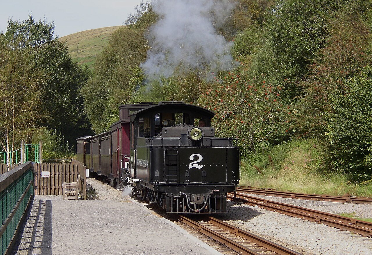
Photo: john bristow · CC BY-SA 2.0 · cropped
The Fox verdict
A small valley base with a remarkable railway story
Pontsticill brings reservoir scenery, a heritage station and a short Taf Fechan forest circuit into one village guide.
The strongest visit combines the railway's reconstructed history with the listed bridge that gave Pontsticill its name. A station café and adventure playground serve running days, while the waymarked river walk adds a 45-minute circuit through tall conifers.
Where to go
Places in Pontsticill
Every place below is checked against a published source, listed with what it is and how long to give it.
Local signatures
3 placesTaf Fechan River Walk
A moderate waymarked circuit through tall conifers beside the Taf Fechan.
- Visit length
- Editorial estimate: about 45 minutes
- Locality
- from Owl’s Grove or Pont Cwmyfedwen car park
- Access
- The route has uneven, muddy stretches, a short wooded descent and a forest-road section.
St Gwynno’s Church, Vaynor
An 1870 church with multicoloured irregular stonework, heavy downhill buttresses, stained glass and Robert Thompson Crawshay’s massive grave slab.
- Visit length
- Editorial estimate: around 30 minutes
- Locality
- Vaynor, near Pontsticill
Cyfarthfa Castle and Park
A nineteenth-century castle, museum and art gallery set in parkland, combining local industrial history with a family outing.
- Visit length
- Editorial estimate: around 90 minutes
- Locality
- Merthyr Tydfil
Food & drink
1 placePontsticill Lakeside Café
The station café serves snacks, drinks and ice cream, with outdoor seating overlooking the reservoir.
- Visit length
- Editorial estimate: around 30 minutes
- Locality
- at the heritage-railway station
- Access
- Open on railway running days.
History & heritage
2 placesPont Sticill Bridge
The single-span stone bridge has an 1825 datestone and preserves the origin of the village name.
- Visit length
- Editorial estimate: around 15 minutes
- Locality
- over the Taf Fechan
Tower of the Old Church of St Gwynno
The surviving west end and battlemented tower of the medieval parish church were retained as a picturesque ruin.
- Visit length
- Editorial estimate: around 20 minutes
- Locality
- Vaynor
Things to do
1 place
Pontsticill Station
A heritage-railway stop with an adventure playground, outdoor seating, accessible toilets and views across Pontsticill Reservoir.
- Visit length
- Editorial estimate: around 35 minutes at the scheduled stop
- Locality
- Pontsticill, a scheduled railway stop
- Access
- Pontsticill is a scheduled stop, but the main boarding point is Pant; station facilities operate on running days.
No places match this filter. Choose All places to reset the list.
Three ways to explore Pontsticill
Signature outings
Meet the railway at Pontsticill
The stripped Brecon and Merthyr route was rebuilt, with the Pant-to-Pontsticill stretch reopening in 1980 behind the small locomotive Sybil.
Pause at the 1825 bridge
The Grade II-listed single stone span gave Pontsticill its name and carries the mountain road over the Taf Fechan.
Look for Crawshay’s grave
At St Gwynno’s, Robert Thompson Crawshay’s grave is a huge quarry-stone slab believed to weigh ten tons and inscribed “God forgive me”.
The village story
Pontsticill: water, stone and a railway rebuilt
The locked Travel Fox article moves from a reservoir-side station and two village pubs to forest routes, the bridge behind the name and the return of the railway.
Reservoir-side arrivals and the Red Cow
The Brecon Mountain Railway pulls in at Pontsticill station with a café beside the platform and an adventure playground behind it, and from the outdoor tables you look straight across Pontsticill Reservoir to the ridges beyond. The café runs on the days the trains run, selling drinks, ice cream and snacks. The village sits in the Taf Fechan valley just below the reservoir, at the southern edge of Bannau Brycheiniog, with conifer forest on one side and open upland on the other. On a clear afternoon the line's operator will tell you Pen y Fan is visible from here.
Two pubs anchor the place. The Red Cow — Y Buwch Coch — is stone-built and stands in the village centre, busy with walkers coming off the hills and people down for the water and the railway. The food is straightforward: a tuna jacket potato with salad, a double cheeseburger with bacon and hand-cut chips, lasagne, Sunday dinner. Dogs come indoors, and there is covered seating out in the car park. Wye Valley Butty Bach is the regular cask beer, with Grey Trees and other Wye Valley beers rotating through the changing taps.
A second table and a self-reliant village
A few hundred metres away, near the reservoir and the station, the Butchers Arms is an independent country pub with a garden that looks out over the water. The kitchen leans Welsh and generous: slow-cooked Welsh Black beef and stout pie, Glamorgan sausages, beer-battered cod, a prime-beef smash burger, a mixed grill and a vegan Penang curry. Two changing cask ales, usually Grey Trees or Butty Bach. There is live music, a small car park and an eighteen-bed bunkhouse arranged across three rooms.
Beyond the pubs, the village looks after itself. The community group keeps the play park, the public toilets, the flower beds and a book exchange going, and has a Green Flag to show for it. Pontsticill has no shop; the station café is the main food outlet outside the pubs.
Routes from riverbank to ridgeline
Walking is a major draw. A waymarked 1.2-mile circular follows the Taf Fechan through tall conifers in about forty-five minutes, muddy and uneven in places. The Taff Trail, the fifty-five-mile Cardiff-to-Brecon route, passes the reservoir on its way north. For the ambitious there is a ten-mile horseshoe over Corn Du, Pen y Fan and Cribyn — full mountain kit, five or six hours, not to be undertaken lightly. Buses 24 and 25 connect the village to Merthyr Tydfil, the nearest mainline station, though the mountain road has been subject to closure, so it is worth checking your route before setting off.
The bridge beneath the village name
The name comes from a bridge. Pont Sticill, a single stone span with an 1825 datestone, still carries the old mountain road over the river. When the valley was flooded for the reservoir in 1927, the Bethlehem chapel went under with it; its congregation held their last service there in September 1925, and when the reservoir level is very low, the ruins can surface again.
A railway rebuilt from bare track
The railway itself is a resurrection. The Brecon and Merthyr line ran from 1863 to 1964, and when it closed the rails, girders and ballast were all stripped out. Anthony Hills rebuilt much of the infrastructure — seven bridges repaired or replaced, the Pontsticill waiting room turned into a workshop — and reopened the Pant-to-Pontsticill stretch in 1980 behind a small locomotive called Sybil. "Dad had a simple vision — to leave something behind for people to enjoy," his son Matthew said of him. "The railway was his life." On running days it still climbs past the village and along the length of the water.
Stay around Brecon Beacons
Make a longer stay of it
Travel Fox holiday homes around Brecon Beacons, linked directly to their property pages.
For homeowners
Own a holiday home near Pontsticill?
We manage holiday lets across the UK from 12% commission, charged after cleaning costs, with no lock-in. A co-founder visits before you decide.
How our holiday let management works →
A guide with a point of view
Written from research. Edited for real journeys.
Use the Official site links for live practical details, then use this guide for context, ideas and room to explore.
Photography credits & licences
Third-party photographs are credited to their named creators and reused under the linked Creative Commons licence or public-domain dedication. Travel Fox stores an optimised local copy; the file-specific changes and any browser-applied display crop are disclosed below. Reused photographs link both to the Wikimedia Commons source record and to the declared source image; Travel Fox's own photographs carry no such record and are marked as ours. These image licences do not cover Travel Fox text, branding or page design.
- File:Brecon Mountain Railway train entering Pontsticill station - geograph.org.uk - 3119317.jpg — photograph by john bristow; Brecon Mountain Railway train entering Pontsticill station by john bristow. Source record on Wikimedia Commons. Declared source image. Licence: CC BY-SA 2.0. File changes: Downloaded from Wikimedia Commons, resized to a maximum 1920px edge and encoded as an optimised JPEG. Display changes: Displayed with responsive CSS cropping.
Sources
Every place on this page is checked against a published source. Each entry links the record we used and names who publishes it.
- Pontsticill Station — bmr.wales other published source
- Pontsticill Lakeside Café — bmr.wales other published source
- Pont Sticill Bridge — cadwpublic-api.azurewebsites.net other published source
- Taf Fechan River Walk — naturalresourceswales.gov.uk statutory register or public authority
- St Gwynno’s Church, Vaynor — coflein.gov.uk statutory register or public authority
- Tower of the Old Church of St Gwynno — cadwpublic-api.azurewebsites.net other published source
- Cyfarthfa Castle and Park — visitmerthyr.co.uk operator, sector body or destination organisation