
Western Rother Valley
Rogate
A South Downs village where a timber-towered church, river meadows and a one-pub centre open onto a long country circuit.
- Best for
- A three-to-four-hour Rother Valley walk
- Give it
- A village half-day or a full day with Uppark
- Don't miss
- St Bartholomew's timber tower
Photo: Simon Burchell · CC BY-SA 4.0 · cropped
The Fox verdict
A small village with a remarkably full day
Rogate pairs a compact historic centre with a substantial Western Rother Valley walk and useful stops on the roads towards Petersfield and South Harting.
Start with St Bartholomew's unusual medieval timber tower, then choose between the National Park's River Rother circuit and a gentler round of the farm shop, recreation ground and White Horse. Petersfield Museum and Uppark add credible nearby options without turning the guide into a list of distant attractions.
Where to go
Places in Rogate
Every place below is checked against a published source, listed with what it is and how long to give it.
Local signatures
3 placesSt Bartholomew's Church
A Grade I church, largely 13th-century, with a surviving round Norman arch and a massive timber-framed tower dated to about 1330.
- Visit length
- Editorial estimate: Allow around 30 minutes
- Locality
- opposite The White Horse on the A272
Durleighmarsh Farm Shop
A family-run farm shop and seasonal pick-your-own, with fruit and vegetables from its own fields alongside food from other local producers.
- Visit length
- Editorial estimate: Allow around 45 minutes
- Locality
- at Durleighmarsh Farm on Rogate Road
- Access
- Pick-your-own is seasonal; check the Official site before travel.
Rogate Circular Walk
The National Park's moderate circuit follows the River Rother and part of the Serpent Trail through patchwork farmland, passing Durford Mill, Wenham Edge and Nyewood.
- Visit length
- Editorial estimate: Allow around 3 hours
- Locality
- through the Western Rother Valley around Rogate
- Access
- This moderate route uses fields, woodland, stiles and bridges; allow three to four hours.
Food & drink
1 place
The White Horse
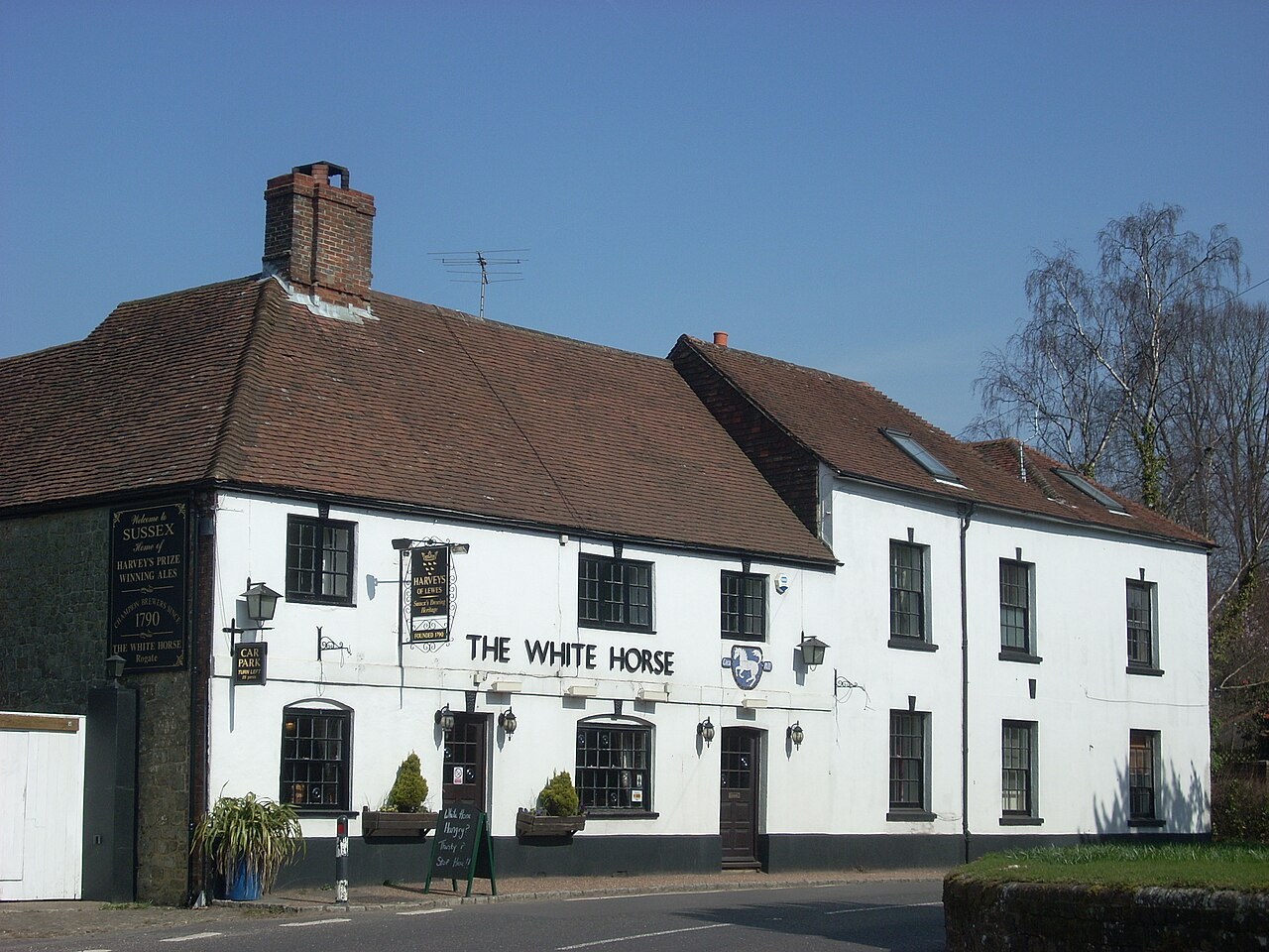
A 16th-century village inn with oak beams, flagstone floors, log fires, four guest rooms, a terrace and a family-friendly garden.
- Visit length
- Editorial estimate: Allow around 75 minutes
- Locality
- opposite St Bartholomew's on the A272
History & heritage
2 placesPetersfield Museum and Art Gallery
A museum and art gallery in Petersfield's former police station and courthouse on St Peter's Road.
- Visit length
- Editorial estimate: Allow around 75 minutes
- Locality
- on St Peter's Road in Petersfield
Uppark House and Garden
A National Trust property combining a 17th-century house, Georgian interiors, a notable dolls' house, gardens, meadow and long views over the Downs.
- Visit length
- Editorial estimate: Allow around 2 hours 30 minutes
- Locality
- near South Harting
- Access
- Check current access arrangements on the Official site before travel.
Things to do
2 placesRogate Village Hall Play Area
A parish-council playground at Rogate Village Hall, useful for a family pause in the village.
- Visit length
- Editorial estimate: Allow around 45 minutes
- Locality
- at Rogate Village Hall
Rogate Village Hall Outdoor Gym
A free-to-use outdoor gym created as a green sports facility beside the village hall play area.
- Visit length
- Editorial estimate: Allow around 30 minutes
- Locality
- adjoining Rogate Village Hall play area
No places match this filter. Choose All places to reset the list.
Three ways to explore Rogate
Signature outings
The village's one-pub welcome
Pause at the 16th-century White Horse for its beamed and flagstoned interior, terrace and family-friendly garden.
A proper valley circuit
Give three to four hours to the National Park's moderate loop through river meadow, farmland and a stretch of the Serpent Trail.
House, garden and horizon
Make Uppark the nearby half-day: a 17th-century house, Georgian interiors, gardens, meadow and long South Downs views.
The village story
Rogate: inn, timber tower and river valley
Eight unchanged paragraphs move from the village's social centre to its medieval church, Western Rother landscape and the people and routes that connect Rogate beyond the A272.
The inn and the village field
The White Horse stands opposite the church on the A272, a 16th-century inn with oak beams, flagstone floors and log fires, and four rooms upstairs if you want to stay put. It is Rogate's pub, and since the old Wyndham Arms stopped pulling pints it is the only one. Harvey's Sussex Best Bitter is one of two regular ales, with a changing beer alongside them, so it's worth checking what's on the pumps. There is a terrace and a garden beside the green, and the pub is glad to have dogs.
Behind it lie the village sports field and a public play park, where you can watch cricket or football depending on the season. The White Horse keeps company with the local darts, football, tennis and bowls clubs and a golf society, which is a lot of organised sport for a village this size.
Farm produce and a travelling tower
Durleighmarsh Farm Shop, just west on Rogate Road, supplies much of the village's provisions. It is family-run, with pick-your-own in season and shelves of fruit and vegetables from the farm's own fields, filled out with food from other local producers.
St Bartholomew's, across the road from the pub, is Grade I listed and largely 13th-century, though a round Norman arch of about 1150 survives inside. Its most striking feature is the timber tower, a massive framed structure carrying a shingled bell-turret and dated to around 1330. During the 1874 rebuilding the whole tower was taken apart piece by piece and re-erected farther west. Moving it exposed a wall painting thought to show the Good Shepherd; only faint feet remain.
Along the Rother and the old railway
The land around the village is river meadow, pasture and hedgerow beneath wooded greensand hills, in the Western Rother Valley inside the South Downs National Park. The National Park Authority invites walkers to "explore patchwork fields, peaceful villages and the scenic River Rother," and its Rogate circular does exactly that: a moderate seven to eight miles, three to four hours, following the Rother and a stretch of the Serpent Trail past Durleighmarsh Farm, Durford Mill and Wenham Edge. Willow and alder line the water, and there is a chance of kingfisher, heron or otter. The Serpent Trail itself runs 65 miles across the heaths, where you may spot adders, lizards and silver-studded blue butterflies.
The walk passes the old Rogate station at Nyewood, on the parish boundary. The Petersfield-to-Midhurst line opened in 1864 and closed in 1955, and the station building still stands. There was an earlier industry too: Tudor iron furnaces and hammers once worked here, supplying the growing Portsmouth naval dockyard until northern coalfields undercut them.
Roads out, and one name remembered
Petersfield, about five miles west, has the nearest station and a museum in the former police station and courthouse on St Peter's Road. Midhurst is six miles east, near the fire-gutted Tudor ruins of Cowdray, and Uppark sits above South Harting to the south, a National Trust house with long views over the Downs. The A272 threads all of this together through the narrow village centre, and Stagecoach route 54 runs between Petersfield and Chichester, calling at Rogate along the way.
Inside the church, one name on the war memorial is Cicily Elger, who nursed wounded soldiers when a nearby house became a temporary hospital during the First World War. She is the only woman, and the only civilian, recorded there.
Stay around South Downs
Make a longer stay of it
Travel Fox holiday homes around South Downs, linked directly to their property pages.
For homeowners
Own a holiday home near Rogate?
We manage holiday lets across the UK from 12% commission, charged after cleaning costs, with no lock-in. A co-founder visits before you decide.
How our holiday let management works →
A guide with a point of view
Written from research. Edited for real journeys.
Use the Official site links for live practical details, then use this guide for context, ideas and room to explore.
Photography credits & licences
Third-party photographs are credited to their named creators and reused under the linked Creative Commons licence or public-domain dedication. Travel Fox stores an optimised local copy; the file-specific changes and any browser-applied display crop are disclosed below. Reused photographs link both to the Wikimedia Commons source record and to the declared source image; Travel Fox's own photographs carry no such record and are marked as ours. These image licences do not cover Travel Fox text, branding or page design.
- File:The White Horse, Rogate 01.jpg — photograph by Simon Burchell; Own work. Source record on Wikimedia Commons. Declared source image. Licence: CC BY-SA 4.0. File changes: Downloaded from Wikimedia Commons, resized to a maximum 1920px edge and encoded as an optimised JPEG. Display changes: Displayed with responsive CSS cropping.
Sources
Every place on this page is checked against a published source. Each entry links the record we used and names who publishes it.
- The White Horse — historicengland.org.uk statutory register or public authority record not machine-readable; publisher restricts automated access
- St Bartholomew's Church — historicengland.org.uk statutory register or public authority record not machine-readable; publisher restricts automated access
- Durleighmarsh Farm Shop — visitpetersfield.co.uk operator, sector body or destination organisation
- Rogate Circular Walk — southdowns.gov.uk statutory register or public authority
- Rogate Village Hall Play Area — rogateparishcouncil.gov.uk statutory register or public authority
- Rogate Village Hall Outdoor Gym — rogateparishcouncil.gov.uk statutory register or public authority
- Petersfield Museum and Art Gallery — petersfieldmuseum.co.uk operator, sector body or destination organisation
- Uppark House and Garden — nationaltrust.org.uk national body or asset manager