
A dale with no through road
Longsleddale
Follow the River Sprint into a narrow farming valley where the single-track road ends beneath open fell.
- Best for
- Quiet valley and fell walking
- Give it
- A prepared half day
- Don't miss
- Gatescarth Pass from the valley head
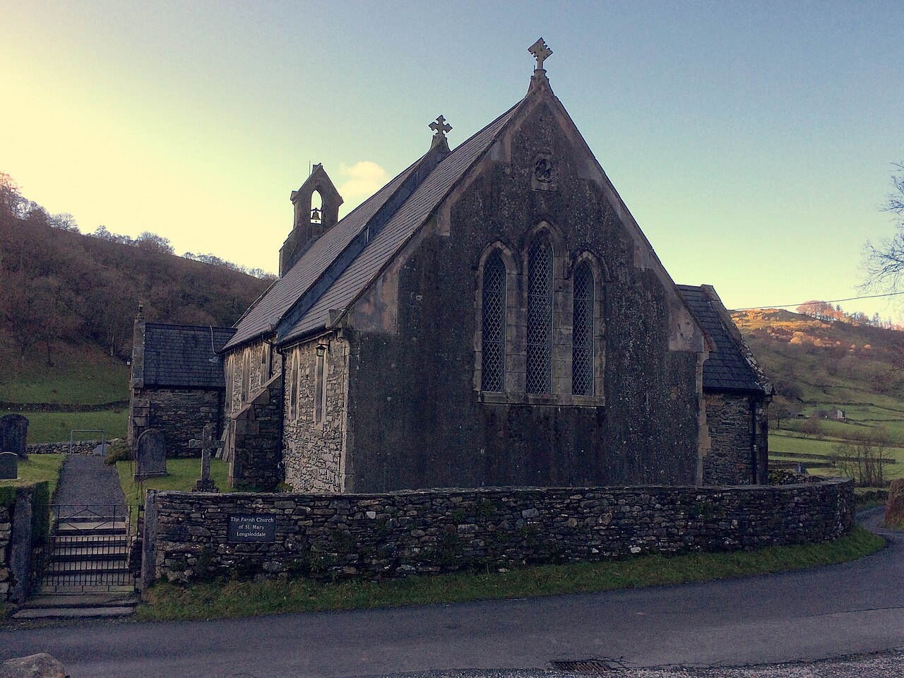
Photo: John H Darch · CC BY-SA 2.0 · cropped
The Fox verdict
Come for the road that runs out
Longsleddale rewards walkers who value a working valley, open moorland and an absence of visitor bustle.
The River Sprint, hay meadows and traditional farms give the dale its character, while Gatescarth Pass and the fells above provide the reason to linger. St Mary's supplies a quiet human focus near the middle of this scattered farming community.
Where to go
Places in Longsleddale
Every place below is checked against a published source, listed with what it is and how long to give it.
Local signatures
3 placesLongsleddale Valley
Explore the quiet valley floor beside the River Sprint, with hay meadows and traditional farms beneath the enclosing fells.
- Visit length
- Editorial estimate: Allow around 75 minutes
- Locality
- along the River Sprint through Longsleddale
- Access
- There is no bus or railway; road access is by the single-track lane from Garnett Bridge.
Gatescarth Pass
Follow the classic high route that carries the old packhorse line over the head of the dale towards Mardale and Haweswater.
- Visit length
- Editorial estimate: Allow around 150 minutes
- Locality
- at the northern head of Longsleddale, beyond Sadgill
St Mary's Church
The focal church of the scattered farming community, on a site with a chapel recorded in 1571 and occupied by the present 1863 building.
- Visit length
- Editorial estimate: Allow around 30 minutes
- Locality
- near the centre of Longsleddale
Walks & outdoors
1 placeSleddale Fell
An open-moorland destination above the dale, with extensive views across the surrounding country.
- Visit length
- Editorial estimate: Allow around 120 minutes
- Locality
- on the fells north of the Longsleddale church and hall
- Access
- Access is on foot over open moorland above the valley.
History & heritage
1 placeWren Gill Quarry
A historic slate-working site that supplemented Longsleddale's hill farming from the eighteenth century into the twentieth century.
- Visit length
- Editorial estimate: Allow around 20 minutes
- Locality
- Wren Gill Slate Quarry, north-west of the Longsleddale church and hall
- Access
- This is a disused slate quarry on the fell. Check current rights of way and ground conditions before setting out.
No places match this filter. Choose All places to reset the list.
Three ways to explore Longsleddale
Signature outings
Climb Sleddale Fell
Head above the valley onto open moorland for extensive views across the surrounding country.
Follow Wren Gill's slate history
The quarry opened by 1728, later returned to work, and supplemented Longsleddale's hill farming.
Step into St Mary's
Visit the church that remains a focal point for Longsleddale's scattered farming community.
The village story
Longsleddale: the valley at the end of the road
An account of a remote farming dale shaped by the River Sprint, fell routes, small industries and its central church.
One road into an unspoiled valley
The road into Longsleddale is single-track and it does not come out the other side. It leaves the A6 at Garnett Bridge, four miles north of Kendal, and runs up a narrow valley before giving up at the open fell. There is no through route. You arrive here on purpose or not at all.
There is no railway and no bus either. The single-track road is the only way in, and the same road is the only way out.
The River Sprint runs the full length of the dale, through hay meadows and the yards of traditional farms. This is a narrow, unspoiled valley in the eastern Lake District, a working hill-farming community, and one of the least-visited valleys in the national park — a fact the single-track road does a good deal to protect.
Bring what you need, then walk
There is no pub. There are no shops. The nearest of either is at Staveley or Kendal, or Shap over the tops, which tells you what kind of place you have come to. There is nowhere to pop out to. Bring what you need.
What Longsleddale has instead is walking. The valley floor itself offers quiet walking, following the Sprint through the meadows and past the farms, with the fell closing in as you go.
The old route over the fells
At the head of the dale, Gatescarth Pass carries the old packhorse route over into Mardale and Haweswater — a classic high crossing, and one people used to make with laden ponies rather than for the view.
Above the valley, Harker Fell and Sleddale Fell open out into moorland, with a lot of country visible from the top and no great crowd to share it with.
Mills, wool and slate
The industry here was always small and always alongside the farming. Two fulling mills were recorded in Longsleddale in 1627, evidence of woollen textile work in the valley.
Wren Gill slate quarry was worked from 1728 until around 1847, then reopened late in the nineteenth century, and was still being cut during the Second World War. It was one of several small industries that supplemented the hill farming here rather than replacing it.
The church at the valley's centre
St Mary's stands near the centre of the valley. A chapel of ease was recorded on the site in 1571, made parochial in 1712, and the present church built in 1863 and renovated in 1903. It is the focal point of this remote and scattered farming community, and it is open every day.
The walks begin from the car park opposite the church door. You cannot really get lost — there is only the one way up, and the same way back.
Stay around Lake District
Make a longer stay of it
Travel Fox holiday homes around Lake District, linked directly to their property pages.
For homeowners
Own a holiday home near Longsleddale?
We manage holiday lets across the Lake District from 12% commission, charged after cleaning costs, with no lock-in. A co-founder visits before you decide.
Holiday let management in the Lake District →
A guide with a point of view
Written from research. Edited for real journeys.
Use the Official site links for live practical details, then use this guide for context, ideas and room to explore.
Photography credits & licences
Third-party photographs are credited to their named creators and reused under the linked Creative Commons licence or public-domain dedication. Travel Fox stores an optimised local copy; the file-specific changes and any browser-applied display crop are disclosed below. Reused photographs link both to the Wikimedia Commons source record and to the declared source image; Travel Fox's own photographs carry no such record and are marked as ours. These image licences do not cover Travel Fox text, branding or page design.
- File:St Mary's Church, Longsleddale - geograph.org.uk - 5242764.jpg — photograph by John H Darch; St Mary's Church, Longsleddale by John H Darch. Source record on Wikimedia Commons. Declared source image. Licence: CC BY-SA 2.0. File changes: Downloaded from Wikimedia Commons, resized to a maximum 1920px edge and encoded as an optimised JPEG. Display changes: Displayed with responsive CSS cropping.
Sources
Every place on this page is checked against a published source. Each entry links the record we used and names who publishes it.
- Longsleddale Valley — lakedistrict.gov.uk statutory register or public authority
- Gatescarth Pass — lakedistrict.gov.uk statutory register or public authority
- Sleddale Fell — ukhillwalking.com other published source
- St Mary's Church — achurchnearyou.com national body or asset manager
- Wren Gill Quarry — cumbriacountyhistory.org.uk other published source