
Chalk downs and village history
Compton
A shallow valley village with two stile-free hill walks, a medieval church and a useful tearoom on The Square.
- Best for
- Stile-free downland walks
- Give it
- A village stop and one three-mile route
- Don't miss
- The hill views and St Mary's medieval details
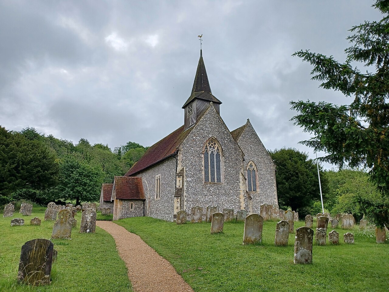
Photo: Simon Burchell · CC BY-SA 4.0 · cropped
The Fox verdict
Come for the walking, stay for the layers of history
Compton pairs two three-mile downland routes with a village tearoom, a medieval church and nearby Uppark.
Choose Telegraph Hill for a long gentle climb and south-coast views, or Compton Down for undulating open country and sheltered West Hanger Wood. Back in the village, Darcy's combines the tearoom and shop, while St Mary's preserves details spanning the late 12th to the 15th centuries.
Your picks, your pace
Make Compton yours
Choose a mood or build your own list. Your saved stops are an ordering aid, with a direct map route when you are ready.
Local signatures
3 placesDarcy's Tea Room
A family-run tearoom and village shop serving homemade cakes and cookies, cooked breakfasts, light bites, afternoon tea, tea and coffee, with groceries on the shop side.
- Visit length
- Editorial estimate: around 60 minutes
- Locality
- The Square, Compton
- Access
- Dogs and children are welcome; check the Official site before relying on current opening details.
St Mary's Church
A principally 13th-century flint church with late-12th-century fabric, a weatherboarded bell turret and shingled spire, plus a 15th-century piscina and plain octagonal font.
- Visit length
- Editorial estimate: around 30 minutes
- Locality
- Compton village
- Access
- Check current visitor access before travel.
Uppark House and Garden
A 17th-century National Trust house with free-to-enter scented borders, a wildflower meadow and views from the South Downs towards the Solent.
- Visit length
- Editorial estimate: around 90 minutes
- Locality
- On the B2146 near Compton
- Access
- Check the Official site for current house and garden access before travel.
Walks & outdoors
2 placesCompton to Telegraph Hill Walk
A three-mile, stile-free route with a long gentle climb and level hilltop stretch, passing Telegraph House and Bevis's Thumb before opening views towards Uppark and the south coast.
- Visit length
- Editorial estimate: Allow about one hour
- Locality
- Between Compton and Telegraph Hill
- Access
- Telegraph House is a residence beside the walk; remain on the public route.
Compton to Compton Down Walk
A three-mile, stile-free route over undulating open downland and arable fields, through sheltered West Hanger Wood, with some steep ascent and long views.
- Visit length
- Editorial estimate: Allow about 90 minutes
- Locality
- Between Compton and Compton Down
No places match this filter. Choose All places to reset the list.
On the map
Compton at a glance
Tap a marker to jump to its guide card.
Three ways to explore Compton
Signature outings
Telegraph Hill panorama
Follow the three-mile, stile-free route past Telegraph House and Bevis's Thumb towards views of Uppark and the south coast.
St Mary's across the centuries
Look for late-12th-century fabric, a 15th-century piscina and the weatherboarded bell turret above the flint walls.
Compton Down and West Hanger Wood
Follow the three-mile, stile-free route across undulating open downland and arable fields, through sheltered West Hanger Wood and towards long views.
The village story
Compton Village Guide
A walking-first village guide shaped by chalk hills, a historic square and centuries of downland history.
A Village Made for Walking
The old village well in the middle of The Square was refurbished in 2000. The village sits in a shallow chalk valley between Telegraph Hill to the east and Compton Down to the west, with farmland and beechwoods rising in every direction. You have come here to walk, and the village is arranged to let you.
Darcy's Tea Room stands on The Square and does the work of two places at once, a family-run tearoom and the village shop. It serves homemade cakes and cookies, cooked breakfasts, light bites and afternoon tea, with freshly made tea and coffee and a specials board that changes daily. The shop side carries local and branded groceries, and both the tearoom and the shop welcome dogs and children.
The Square and St Mary's
The Coach & Horses on the same Square is closed. A former coaching inn that has stood since the 16th century and has been an inn since the 1660s, it reopened after restoration in 2022 and is now shut long-term, marketed on a new lease, so do not plan an evening around it. A century ago the village supported more: a butcher, a second shop, and a place called Cobbys that sold boots, clothes and lino alongside home-cured bacon, home-baked bread, sweets and cream from its own cows.
St Mary's church is principally 13th century, listed Grade II*, though a blocked north arcade and a waterleaf capital survive from the late 12th century and much of what you see followed a heavy restoration in 1849. The walls are flint with stone dressings under a tiled roof, and a weatherboarded bell turret carries a shingled spire at the west end. Inside are a 15th-century trefoil-headed piscina, a plain octagonal font, and an organ by H. Willis & Son installed in 1970.
Across the Downs
The walking is the point. From the Recreation Ground, about two hundred yards south of The Square on the B2146, there is free parking and a choice of routes with no stiles on any of them. The three-mile climb to Telegraph Hill is a long gentle pull with a level hilltop stretch, passing Telegraph House and Bevis's Thumb and opening out towards Uppark and the south coast. A similar distance west takes you over undulating downland and through the sheltered West Hanger Wood onto Compton Down, with views reaching to Portsmouth, the Spinnaker Tower and the Isle of Wight. A longer 5.9-mile circular loops out through North Marden and Up Marden on exposed tracks with almost no road walking.
Bevis's Thumb, out between Fernbeds Down and Telegraph Hill, is an early Neolithic long barrow around sixty metres long, among the longest in south-east England. Telegraph Hill earned its name from a semaphore station built in 1821, the twelfth of fifteen relaying Admiralty signals between London and Portsmouth from 1822 until 1847. Telegraph House stands on the site now and is a private home.
Deep History and Practical Access
Compton reaches a long way back. It appears in King Alfred's will, and the Domesday surveyors of 1086 recorded twenty-eight households here, one of them a priest, on its main holding, valued at eight pounds. On the downs at Apple Down, metal-detector finds in the 1980s led to the excavation of a mixed-rite pagan cemetery in use from the late fifth to the seventh century.
Getting here is easiest on Stagecoach route 54, which links the village with Chichester, South Harting, Rogate and Petersfield station Monday to Saturday; there is currently no Sunday service, so check times before you travel. The same route stops at the gates of Uppark, the National Trust house up the B2146, whose scented borders and meadow are free to walk. On VE Day in 1945, one resident remembered, "that night the square was alight with blazing torches and the dancing went on until the early hours."
Stay around South Downs
Make a longer stay of it
Travel Fox holiday homes around South Downs, linked directly to their property pages.
For homeowners
Own a holiday home near Compton?
We manage holiday lets across the UK from 12% commission, charged after cleaning costs, with no lock-in. A co-founder visits before you decide.
How our holiday let management works →
A guide with a point of view
Written from research. Edited for real journeys.
Use the Official site links for live practical details, then use this guide for context, ideas and room to explore.
Photography credits & licences
Third-party photographs are credited to their named creators and reused under the linked Creative Commons licence or public-domain dedication. Travel Fox stores an optimised local copy; the file-specific changes and any browser-applied display crop are disclosed below. Reused photographs link both to the Wikimedia Commons source record and to the declared source image; Travel Fox's own photographs carry no such record and are marked as ours. These image licences do not cover Travel Fox text, branding or page design.
- File:St. Mary's Church, Compton, West Sussex 02.jpg — photograph by Simon Burchell; Own work. Source record on Wikimedia Commons. Declared source image. Licence: CC BY-SA 4.0. File changes: Downloaded from Wikimedia Commons, resized to a maximum 1920px edge and encoded as an optimised JPEG. Display changes: Displayed with responsive CSS cropping.
Sources
Every place on this page is checked against a published source. Each entry links the record we used and names who publishes it.
- Darcy's Tea Room — darcys-tearoom.com operator, sector body or destination organisation
- St Mary's Church — historicengland.org.uk statutory register or public authority record not machine-readable; publisher restricts automated access
- Compton to Telegraph Hill Walk — bournetrail.co.uk other published source
- Compton to Compton Down Walk — bournetrail.co.uk other published source
- Uppark House and Garden — nationaltrust.org.uk national body or asset manager