
Built on the Clyde
Clydebank
A waterfront town shaped by shipbuilding, Singer sewing machines, the Blitz and the canal threading through it.
- Best for
- Industrial history and waterside walking
- Give it
- A focused half day
- Don't miss
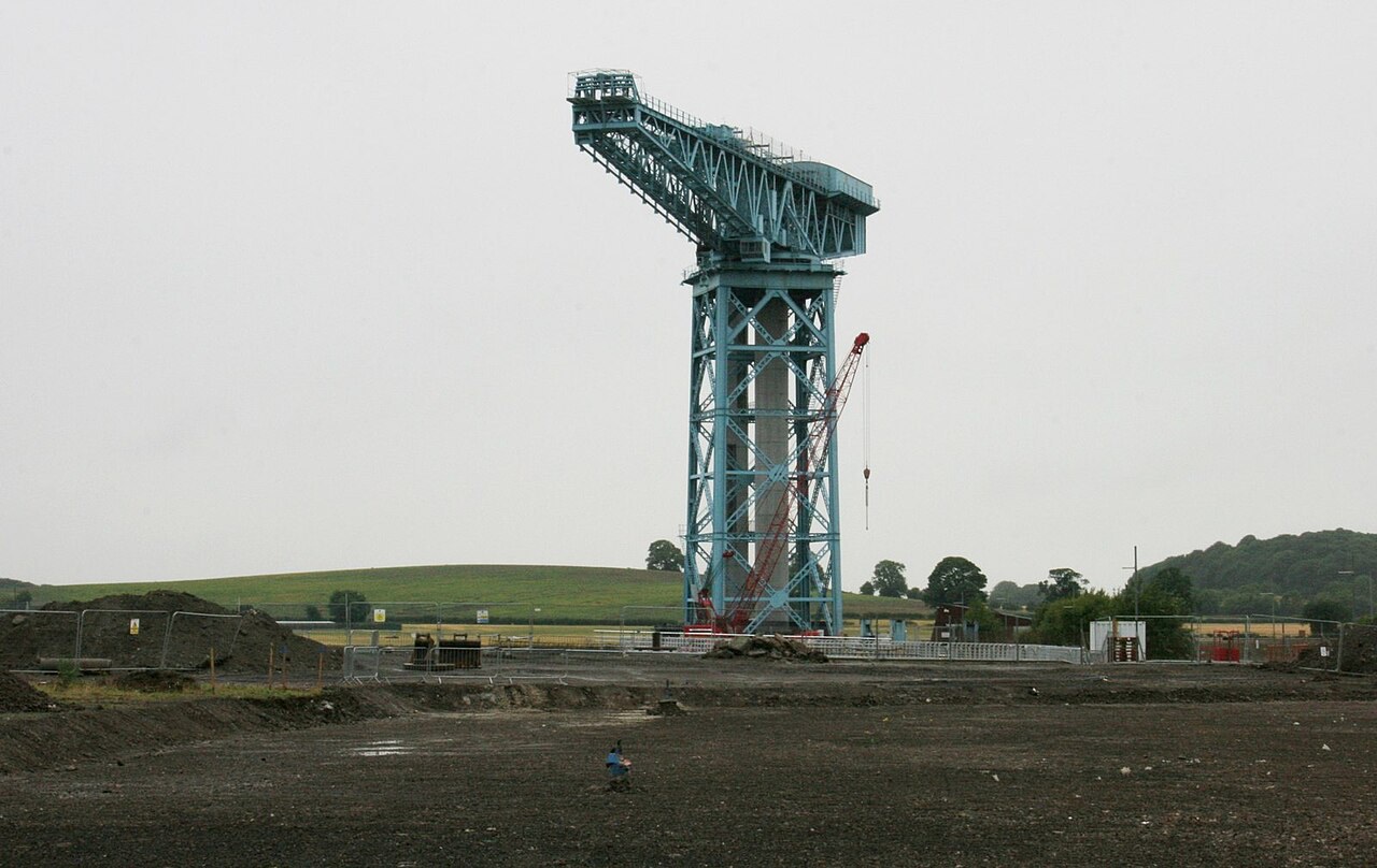
- Titan Crane above the shipyard waterfront
Photo: Richard Sutcliffe · CC BY-SA 2.0 · cropped
The Fox verdict
A town engineered by shipyards and Singer
Clydebank's strongest visits connect the monumental Titan Crane with canal walking and the town's industrial story.
John Brown's shipyard and the Singer works made Clydebank, while the 1941 Blitz left a defining scar. The restored Titan Crane, Forth and Clyde Canal, Goldenhill Park's Antonine Wall remains and the Kilpatrick Hills turn that history and landscape into a varied visit.
Where to go
Places in Clydebank
Every place below is checked against a published source, listed with what it is and how long to give it.
Local signatures
3 places
Start here
Titan Clydebank
A restored Category A-listed cantilever crane with a viewing platform, built to lift engines and boilers into ships including Hood, Queen Mary, Queen Elizabeth, QE2 and Britannia.
- Visit length
- Editorial estimate: Allow around 75 minutes
- Locality
- redeveloped shipyard waterfront at Queen's Quay
Forth and Clyde Canal Towpath
The level towpath provides flat walking and cycling, west towards Bowling's basin and sea lock or east towards Glasgow.
- Visit length
- Editorial estimate: Allow around 90 minutes
- Locality
- passes through Clydebank
Clyde Shopping Centre
Clydebank's covered shopping centre, first opened in 1982, supports indoor family shopping and eating on the former Singer works site.
- Visit length
- Editorial estimate: Allow around 75 minutes
- Locality
- former Singer works site
Walks & outdoors
2 placesBowling Harbour
The western canal harbour where the Forth and Clyde Canal widens into a basin and meets the River Clyde at the sea lock.
- Visit length
- Editorial estimate: Allow around 75 minutes
- Locality
- Bowling
Kilpatrick Hills
The hills rising north of Clydebank provide the higher, upland walking option in contrast to the level canal towpath.
- Visit length
- Editorial estimate: Allow around 150 minutes
- Locality
- beyond Duntocher, Hardgate and Faifley
History & heritage
2 placesGoldenhill Park
A park where the exposed stone base of the Antonine Wall can be walked and viewed, with displayed millstones recalling Duntocher's cotton-mill past.
- Visit length
- Editorial estimate: Allow around 60 minutes
- Locality
- Duntocher
Dumbarton Castle
A stronghold on a 240-foot basalt volcanic plug, with a medieval Portcullis Arch and 627 steps to the White Tower Crag summit.
- Visit length
- Editorial estimate: Allow around 120 minutes
- Locality
- Dumbarton Rock
No places match this filter. Choose All places to reset the list.
Three ways to explore Clydebank
Signature outings
Take in Titan Clydebank
Use the viewing platform on the restored cantilever crane that once lifted engines and boilers into John Brown's ships.
Trace the wall at Goldenhill
Walk and view the Antonine Wall's exposed stone base, then find the displayed millstones from Duntocher's cotton-mill past.
Scale Dumbarton Rock
Climb the 627 steps to White Tower Crag on the 240-foot volcanic plug occupied by Dumbarton Castle.
The town story
Clydebank Town Guide
The story of a Clyde town made by cranes, liners, sewing machines and endurance.
The crane and the ships
The Titan Crane stands 161 feet above the waterfront, painted, riveted and no longer lifting anything. When it was finished in 1907 it was the world's first electrically powered cantilever crane and the largest of its type, built to lower engines and boilers into the ships below. A lift now takes you to the viewing platform, and since 2015 you can jump off it on a bungee rope.
The ships it served came from John Brown & Company, the shipyard that made the town. The Queen Mary, the Queen Elizabeth, the QE2 and the Royal Yacht Britannia were all built here, along with the Lusitania and HMS Hood. J & G Thomson had moved their Clyde Bank yard onto this flat land in 1871, and the workers who followed lived in tenements they nicknamed Tamson's Buildings. The yard joined Upper Clyde Shipbuilders, staged the 1971 work-in under Jimmy Reid, and closed in 2000.
Singer, canal and Roman frontier
The other great employer was Singer, whose sewing-machine works at Kilbowie once held around 11,000 people before closing in 1980. The Clyde Shopping Centre is built on the site: a covered centre that opened in 1982 and, after refurbishment, was reopened by Queen Elizabeth II in 2003. The Clydebank Co-operative Society keeps outlets in the town.
For walking, the Forth and Clyde Canal threads straight through Clydebank and gives you a level towpath in either direction — west to Bowling, where the canal widens into a basin and drops through a sea lock into the Clyde, or east toward Glasgow. The John Muir Way follows the same waterfront corridor on its way across Scotland. North of the town, beyond Duntocher and Faifley, the Kilpatrick Hills rise for higher walking. At Goldenhill Park in Duntocher you can walk the exposed stone base of the Antonine Wall, the Roman frontier that ran through here and has been a UNESCO World Heritage Site since 2008; displayed millstones nearby recall the village's cotton-mill past.
The night the Blitz came
The town's defining night was 13–14 March 1941, when the Luftwaffe raided over two nights and killed 528 civilians, seriously injuring more than 617 — one of the worst raids Scotland saw. The Linnvale scheme was rebuilt afterwards, its streets named for Attlee's government: Attlee Avenue, Bevin Avenue.
Four stations and wider horizons
Getting here is easy. Four stations — Clydebank, Dalmuir, Singer and Drumry — run frequent trains to Glasgow, six and a half miles east, and the Erskine Bridge carries the A82 across the Clyde toward the M8 and the airport. Loch Lomond's southern gateway is twenty to thirty minutes north-west. Dumbarton Castle sits seven miles west on a 240-foot volcanic plug, with 627 steps up to the White Tower Crag and, its keepers claim, the longest recorded history of any stronghold in Scotland.
A band chooses music
Wet Wet Wet formed in Clydebank in 1982. Their bassist, Graeme Clark, once explained the choice this way: "It was either crime, the dole, football, or music...and we chose music."
Stay around West Dunbartonshire
Make a longer stay of it
Travel Fox holiday homes around West Dunbartonshire, linked directly to their property pages.
For homeowners
Own a holiday home near Clydebank?
We manage holiday lets across the UK from 12% commission, charged after cleaning costs, with no lock-in. A co-founder visits before you decide.
How our holiday let management works →
A guide with a point of view
Written from research. Edited for real journeys.
Use the Official site links for live practical details, then use this guide for context, ideas and room to explore.
Photography credits & licences
Third-party photographs are credited to their named creators and reused under the linked Creative Commons licence or public-domain dedication. Travel Fox stores an optimised local copy; the file-specific changes and any browser-applied display crop are disclosed below. Reused photographs link both to the Wikimedia Commons source record and to the declared source image; Travel Fox's own photographs carry no such record and are marked as ours. These image licences do not cover Travel Fox text, branding or page design.
- File:Titan crane, Clydebank - geograph.org.uk - 5858492.jpg — photograph by Richard Sutcliffe; Titan crane, Clydebank by Richard Sutcliffe. Source record on Wikimedia Commons. Declared source image. Licence: CC BY-SA 2.0. File changes: Downloaded from Wikimedia Commons, resized to a maximum 1920px edge and encoded as an optimised JPEG. Display changes: Displayed with responsive CSS cropping.
Sources
Every place on this page is checked against a published source. Each entry links the record we used and names who publishes it.
- Titan Clydebank — portal.historicenvironment.scot statutory register or public authority
- Forth and Clyde Canal Towpath — scottishcanals.co.uk operator, sector body or destination organisation
- Goldenhill Park — antoninewall.org other published source
- Clyde Shopping Centre — clyde-shoppingcentre.co.uk operator, sector body or destination organisation
- Dumbarton Castle — historicenvironment.scot statutory register or public authority record not machine-readable; publisher restricts automated access
- Bowling Harbour — scottishcanals.co.uk other published source
- Kilpatrick Hills — west-dunbarton.gov.uk statutory register or public authority